Heretaunga Plains

Heretaunga Plains
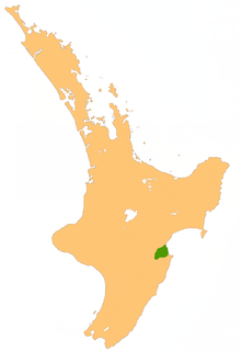
Lage der Heretaunga Plains

Die Heretaunga Plains sind eine Ebene im Osten der Nordinsel Neuseelands.

Das Schwemmland der Ebene wurde von den Flüssen Tutaekuri, Ngaruroro und Tukituki River im Bereich ihres Unterlaufes am Südende der in den Pazifik mündenden Hawke Bay abgelagert.

Der Tutaekuri River verläuft östlich der Kaweka Range und mündet unmittelbar südlich von Napier. Der Ngaruroro River verläuft etwa 100 km südöstlich der Kaweka Range, danach ostwärts. Er mündet 10 km südlich von Napier bei der Stadt Clive. Der Tukituki River entspringt den Ruahine Ranges und fließt über eine Strecke von 105 km zuerst nach Osten, dann nach Nordosten. Er passiert dabei die Stadt Waipukurau und mündet nahe Hastings in die Hawke Bay.

Die Ebene erstreckt sich nach Südwesten landeinwärts und hat eine Fläche von etwa 1000 km². Die Städte Napier, Hastings und Havelock North liegen in der Ebene, die sich fast bis zur größten Stadt des Distrikts, Waipukurau, ausdehnt.

Der fruchtbare Boden und das warme, trockene Klima der Region schaffen gute Voraussetzungen für den Weinanbau, Obstanbau und Gartenbau. Die südliche Region Hawke's Bay ist eines der besten Weinbaugebiete Neuseelands.


Wikimedia Foundation.

Игры ⚽ Нужна курсовая?

Schlagen Sie auch in anderen Wörterbüchern nach:

  • Heretaunga Plains — The Heretaunga Plains are an area of flat land in the eastern North Island of New Zealand. The alluvial plains were formed by the Tutaekuri, Ngaruroro and Tukituki Rivers as they flow to the Pacific Ocean at the southern end of Hawke Bay. They… …   Wikipedia

  • Hastings, New Zealand — Infobox Settlement name=Hastings native name=Heretaunga (Maori) total type=Territorial pushpin pushpin label position = right pushpin map caption = Hastings pushpin mapsize = 180 subdivision type= Country subdivision name= NZL subdivision type1=… …   Wikipedia

  • Havelock North — Havelock North …   Deutsch Wikipedia

  • Hawke's Bay — Hawke’s Bay Karte Basisdaten Hauptstadt: Napier …   Deutsch Wikipedia

  • NZ-HKB — Hawke’s Bay Karte Basisdaten Hauptstadt: Napier …   Deutsch Wikipedia

  • Ngaruroro River — Lage der Heretaunga Plains Die Heretaunga Plains sind eine Ebene im Osten der Nordinsel Neuseelands. Das Schwemmland der Ebene wurde von den Flüssen Tutaekuri, Ngaruroro und Tukituki River im Bereich ihres Unterlaufes am Südende der in den… …   Deutsch Wikipedia

  • Tutaekuri River — Lage der Heretaunga Plains Die Heretaunga Plains sind eine Ebene im Osten der Nordinsel Neuseelands. Das Schwemmland der Ebene wurde von den Flüssen Tutaekuri, Ngaruroro und Tukituki River im Bereich ihres Unterlaufes am Südende der in den… …   Deutsch Wikipedia

  • Hawke's Bay — ( mi. Heretaunga) is a region of New Zealand. Hawke s Bay is recognised on the world stage for its award winning wines. The regional council sits in both the cities of Napier and Hastings.GeographyThe region is situated on the east coast of the… …   Wikipedia

  • Havelock North, New Zealand — Havelock North is a town in New Zealand, in the North Island s Hawke s Bay region. It ranked as a borough for many years until the 1989 reorganisation of local government saw it merged into the new Hastings District. Location, features and… …   Wikipedia

  • Hawke’s Bay — Karte Basisdaten Haup …   Deutsch Wikipedia

Share the article and excerpts

Direct link
Do a right-click on the link above
and select “Copy Link”