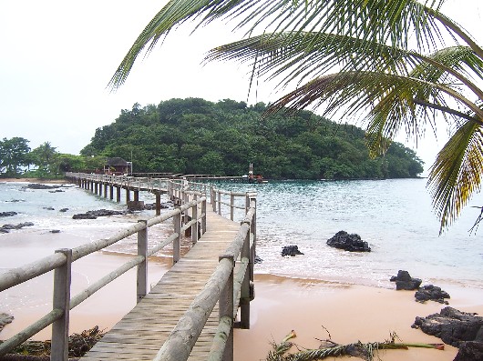
Ilheu Bom Bom — Ilhéu Bom Bom, also Ilhéu Bombom is an island in the Gulf of Guinea. The islet is located north of the coast of the island of Príncipe, one of the main islands of São Tomé and Príncipe. The island includes a couple of tourist resorts in São Tomé… … Wikipedia
Ilhéu Bom Bom — Vorlage:Infobox Insel/Wartung/Fläche fehltVorlage:Infobox Insel/Wartung/Höhe fehlt Ilhéu Bom Bom Gewässer … Deutsch Wikipedia
Ilhéu Bombom — Ilhéu Bom Bom o Ilhéu Bombom es un islote que pertenece al país de Santo Tomé y Príncipe, en el Golfo de Guinea. El islote se encuenta al norte de la costa de la isla de Príncipe, a 1º N 7º O. Incluye un par de centros turísticos. No hay… … Wikipedia Español
Ilhéu Bombom — Karte von São Tomé und Príncipe Ilheu Bom Bom ganz im Norden Ilheu Bom Bom ist eine Insel im Golf von Guinea. Sie liegt vor der Nordküste von Príncipe, einer der beiden Hauptinseln des Inselstaats … Deutsch Wikipedia
Inter Bom-Bom — Football club infobox clubname = Inter Bom Bom nickname = Unknown fullname = Inter Bom Bom founded = N/A ground = São Tomé Island, São Tomé and Principe capacity = N/A chairman = N/A manager = N/A league = São Tomé Island League season = 2007… … Wikipedia
List of São Tomé and Príncipe-related topics — This is a partial list of topics related to São Tomé and Príncipe. Geography * Extreme points of São Tomé and Príncipe * List of volcanoes in São Tomé and Príncipe Landforms Islands * Ilheu Bom Bom * Ilhéu das Cabras * Ilhéu Caroço * Ilhéu das… … Wikipedia
Pagué — Príncipe Basisdaten Hauptstadt: Santo António Fläche: 142 km² … Deutsch Wikipedia
Principe — Príncipe Basisdaten Hauptstadt: Santo António Fläche: 142 km² … Deutsch Wikipedia
Príncipe — Infobox STP provinces capital=Santo António area=136 km² lowest=Atlantic Ocean centre=Santo António highest=Pico de Príncipe (948 m) population=around 5,000 density=about 36 totaldistricts=1 (Pagué) phone number=19x xxxx? inhabitants=Príncipean… … Wikipedia
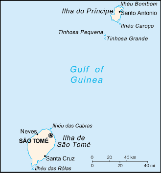
Liste der Inseln von São Tomé und Príncipe — Karte mit den wichtigsten Inseln von São Tomé und Príncipe Die Liste der Inseln von São Tomé und Príncipe enthält die Inseln, aus denen der Staat São Tomé und Príncipe im Atlantik vor der Küste Zentralafrikas besteht. Ilhéu Bom Bom Ilhéu das… … Deutsch Wikipedia
 Karte von São Tomé und Príncipe - Ilheu Bom Bom ganz im Norden