- Amphoe Chon Daen
-
Chon Daen
ชนแดนProvinz: Phetchabun Fläche: 1.137 km² Einwohner: 86.086 (2000) Bev.dichte: 76 E./km² PLZ: 67150 Geocode: 6702 Karte 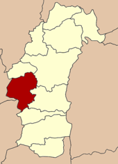
Amphoe Chon Daen (Thai อำเภอ ชนแดน) ist ein Landkreis (Amphoe - Verwaltungs-Distrikt) der Provinz Phetchabun. Die Provinz Phetchabun liegt im südöstlichen Teil der Nordregion von Thailand.
Inhaltsverzeichnis
Geographie
Amphoe Chon Daen liegt im Westen der Provinz Phetchabun und grenzt vom Norden aus im Uhrzeigersinn gesehen an die Amphoe Wang Pong, Mueang Phetchabun, Nong Phai und Bueng Sam Phan in der Provinz Phetchabun, Nong Bua in der Provinz Nakhon Sawan sowie Dong Charoen und Thap Khlo in der Provinz Phichit.
Geschichte
Chon Daen wurde 1917 zunächst als Kleinbezirk (King Amphoe) geschaffen. 1956 erfolgte die Erhebung zu einem vollen Bezirk (Amphoe).
Verwaltung
Amphoe Chon Daen besteht aus neun Unterbezirken (Tambon), die weiter in 125 Dörfer (Muban) gegliedert sind.
Es gibt drei Kleinstädte (Thesaban Tambon) im Landkreis:
- Chon Daen (Thai: เทศบาลตำบลชนแดน) besteht aus Teilen des Tambon Chon Daen,
- Dong Khui (Thai: เทศบาลตำบลดงขุย) besteht aus Teilen der Tambon Dong Khui und Takut Rai,
- Tha Kham (Thai: เทศบาลตำบลท่าข้าม) besteht aus Teilen des Tambon Tha Kham.
Außerdem gibt es neun „Tambon Administrative Organizations“ (TAO, องค์การบริหารส่วนตำบล – Verwaltungs-Organisationen) im Landkreis.
Nr. Name Thai 1. Chon Daen ชนแดน 2. Dong Khui ดงขุย 3. Tha Kham ท่าข้าม 4. Phutthabat พุทธบาท 5. Lat Khae ลาดแค 6. Ban Kluai บ้านกล้วย 8. Sap Phutsa ซับพุทรา 9. Takut Rai ตะกุดไร 10. Sala Lai ศาลาลาย Weblinks
Amphoe von PhetchabunAmphoe: Mueang Phetchabun | Bueng Sam Phan | Chon Daen | Khao Kho | Lom Kao | Lom Sak | Nam Nao | Nong Phai | Si Thep | Wang Pong | Wichian Buri
Wikimedia Foundation.
Schlagen Sie auch in anderen Wörterbüchern nach:
Amphoe Chon Daen — Admin ASC 2 Code Orig. name Amphoe Chon Daen Country and Admin Code TH.14.1611105 TH … World countries Adminstrative division ASC I-II
Amphoe Chon Daen — Infobox Amphoe name=Chon Daen thai=ชนแดน province=Phetchabun coordinates=coord|16|11|21|N|100|51|35|E|type:adm2nd region:TH area=1,137.0 population=86,086 population as of=2000 density=75.7 postal code=67150 geocode=6702Chon Daen ( th. ชนแดน) is… … Wikipedia
Chon Daen — ชนแดน Provinz: Phetchabun Fläche: 1.137 km² Einwohner: 86.086 (2000) Bev.dichte: 76 E./km² PLZ: 67150 … Deutsch Wikipedia
Chon Daen — Original name in latin Chon Daen Name in other language Amphoe Chon Daen, Ban Chon Daen, Ban Chon Dean, Bn Chon Dean, Chon Daen, Jonden, Jondn, King Amphoe Chon Daen, King Chon Daen State code TH Continent/City Asia/Bangkok longitude 16.18953… … Cities with a population over 1000 database
Chon Daen District — Chon Daen ชนแดน Amphoe Amphoe location in Phetchabun Province … Wikipedia
Amphoe Wang Pong — Wang Pong วังโป่ง Provinz: Phetchabun Fläche: 543 km² Einwohner: 38.473 (2005) Bev.dichte: 71 E./km² PLZ: 67240 … Deutsch Wikipedia
Amphoe Bueng Sam Phan — Bueng Sam Phan บึงสามพัน Provinz: Phetchabun Fläche: 489,8 km² Einwohner: 66.613 (2000) Bev.dichte: 136 E./km² PLZ: 67160 … Deutsch Wikipedia
Amphoe Nong Bua — Nong Bua หนองบัว Provinz: Nakhon Sawan Fläche: 819,5 km² Einwohner: 70.609 (2005) Bev.dichte: 86,2 E./km² PLZ: 60110 … Deutsch Wikipedia
Amphoe Mueang Phetchabun — Mueang Phetchabun เมืองเพชรบูรณ์ Provinz: Phetchabun Fläche: 2281 km² Einwohner: 211.227 (2000) Bev.dichte: 92,6 E./km² PLZ … Deutsch Wikipedia
Amphoe Nong Phai — Nong Phai หนองไผ Provinz: Phetchabun Fläche: 1.360,2 km² Einwohner: 115.832 (200) Bev.dichte: 85 E./km² PLZ: 67140 … Deutsch Wikipedia
Amphoe Chon Daen

18+
© Academic, 2000-2026
- Kontaktieren Sie uns: Unterstützung, Werbung
Wörterbücher Export, schritte mit PHP, Joomla, Drupal, WordPress, MODx.