- Kanadisch-arktische Inseln
-
Der kanadisch-arktische Archipel ist die nördliche Inselwelt von Kanada. Er liegt im Norden von Kanada und grenzt an Grönland. Er ist größtenteils unbewohnt.
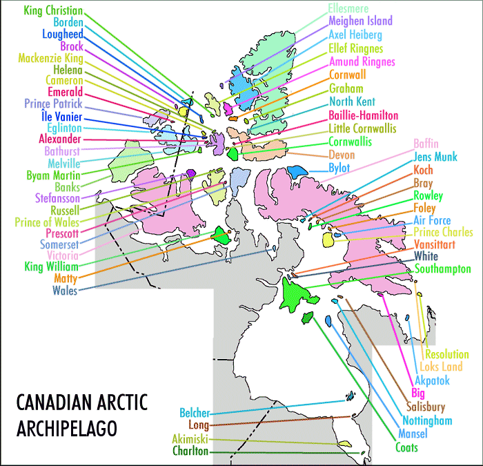
Die Königin-Elisabeth-Inseln sind mit einer Gesamtfläche von über 400.000 km² die größte Inselgruppe des Archipels, weitere große Inseln sind z. B. die Baffininsel, die Victoria-Insel und die Banksinsel.
Name Territorium* Fläche Rangliste Bevölkerung
(2001)weltweit Kanada Baffin Island  NU
NU507451 km² 5 1 9563 Victoria Island  NT, NU
217291 km² 9 2 1707 Ellesmere Island NU196236 km² 10 3 168 Banks Island NT70028 km² 24 5 114 Devon Island NU55247 km² 27 6 0 Axel Heiberg Island NU43178 km² 32 7 0 Melville Island NT, NU42149 km² 33 8 0 Southampton Island NU41214 km² 34 9 721 Prince of Wales Island NU33339 km² 40 10 0 Somerset Island NU24786 km² 46 12 0 Bathurst Island NU16042 km² 54 13 0 Prince Patrick Island NT15848 km² 55 14 0 King William Island NU13111 km² 61 15 960 Ellef Ringnes Island NU11295 km² 69 16 0 Bylot Island NU11067 km² 72 17 0 * NT = Nordwest-Territorien , NU = Nunavut
Weblinks
Amund-Ringnes-Insel | Axel-Heiberg-Insel | Bathurst-Insel | Borden-Insel | Brock-Insel | Byam-Martin-Insel | Cameron-Insel | Coburg-Insel | Cornwall-Insel | Cornwallis-Insel | Devon-Insel | Eglinton-Insel | Ellef-Ringnes-Insel | Ellesmere-Insel | Emerald-Insel | Graham-Insel | König-Christian-Insel | Lougheed-Insel | Mackenzie-King-Insel | Meighen-Insel | Melville-Insel | Prinz-Patrick-Insel
Wikimedia Foundation.