- Kasungu
-
Kasungu 

Kasungu 
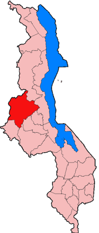
Basisdaten Staat Malawi Fläche – Metropolregion 7.878 km² Einwohner 45.555 (2006) Metropolregion 480.659 (2003) Dichte – Metropolregion 61 Ew./km² ISO 3166-2 MW -13.03333333333333.484722222222Koordinaten: 13° 2′ S, 33° 29′ OKasungu ist eine Stadt in 1200 Meter Höhe in der Zentralregion von Malawi und hat etwa 45.555 Einwohner (Schätzung 2006). Sie ist Hauptstadt des gleichnamigen Distrikts, der eine Fläche von 7878 km² und eine Bevölkerung von 480.659 (2003) hat. Kasungu ist an das nationale Stromnetz angeschlossen. Ein eigenes Staubecken dient der Trinkwasserversorgung. 20 Kilometer westlich der Stadt beginnt der Kasungu-Nationalpark, der eine hohe Tierdichte hat. Dort gibt es eine Lodge mit Gastronomie und Übernachtungsmöglichkeit für den gehobenen Tourismus.
Der Distrikt Kasungu liegt im erodierten Hochland über dem Dwangwa-Tal, auch Sand-Feld genannt, das nach Süden bis Dowa reicht. Es ist ein Gebiet von Subsistenz und Hunger. Mit Chiradzulu und Mulanje teilt er die untersten Ränge der Ernährungssicherheit im Land.
Kasungu hat eine asphaltierte 1200 Meter lange und 17 Meter breite Landebahn für Flugzeuge, einen Wochenmarkt, einen Supermarkt, ein Hotel, eine Tankstelle, Grund- und Sekundarschulen, die einzige Blindenschule Malawis – geleitet von der Christoffel-Blindenmission – und ein Krankenhaus.
Kategorie:- Ort in Malawi

Wikimedia Foundation.