Kempenfelt Bay — is a 14.5 km long bay that leads into the Canadian city of Barrie, Ontario. It is as deep as 30 m in places, and is connected to the larger Lake Simcoe. It is known for its ice fishing and legends of Kempenfelt Kelly, a Loch Ness monster style… … Wikipedia
Richard Kempenfelt — Infobox Person name= Richard Kempenfelt caption= Portait as a Rear Admiral birth date= 1718 birth place= Westminster, London, England death date= death date|1782|4|29|df=y death place=Spithead, England occupation = Royal Navy AdmiralRichard… … Wikipedia
HMS Kempenfelt (R03) — HMS Kempenfelt was a W Class destroyer flotilla leader of the Royal Navy that served in the Second World War. She was the second destroyer of her name to have served in the war; the first Kempenfelt was transferred to the Royal Canadian Navy in… … Wikipedia
Barrie — For the electoral district, see Barrie (electoral district). For other uses, see Barrie (disambiguation). Barrie Independent city … Wikipedia
Yonge Street — (pronounced young ) is a major arterial street in Toronto, Ontario, Canada, and its northern suburbs. It was formerly listed in the Guinness Book of Records as the longest street in the world, [ [http://ask.yahoo.com/ask/20021121.html What is the … Wikipedia
Bradford, Ontario — Bradford is the primary country urban area of the Town of Bradford West Gwillimbury, Ontario, in Canada. It overlooks a beautiful and prosperous farming community, known as The Holland Marsh, located on the Holland River that flows into Lake… … Wikipedia
Ontario Highway 93 — Highway 93 Route information Maintained by the Ministry of Transportation of Ontario Length: 24.1 km (15.0 mi) … Wikipedia
Penetanguishene Road — now Highway 93, and Simcoe County Road 93, built between 1814 15, from the north side of Kempenfelt Bay (east of Barrie), to the townsite and Naval establishment at Penetanguishene, was the first road constructed in what is now Simcoe County,… … Wikipedia
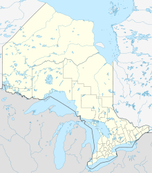
Lake Simcoe — Infobox lake lake name = Lake Simcoe image lake = Simcoe 79.40W 44.47N.png caption lake = satellite view image bathymetry = caption bathymetry = location = Ontario coords = coord|44|26|12|N|079|20|21|W|type:waterbody region:CA… … Wikipedia
Innisfil — Not to be confused with Innisfail Town of Innisfil Town hall Motto: Where Opportunity Meets Prosperity … Wikipedia
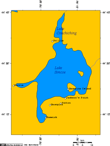 Karte des Lake Simcoe mit Kempenfelt Bay im Westen
 44.38571-79.61449Koordinaten: 44° 23′ 9″ N, 79° 36′ 52″ W