Kuskokwim Mountains

Kuskokwim Mountains

p1f1p3

Kuskokwim Mountains
Lage Alaska (USA)
Kuskokwim Mountains (Alaska)
Kuskokwim Mountains
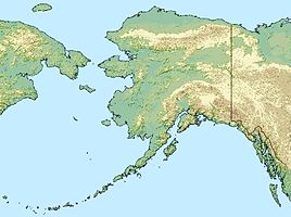
Koordinaten 63° 0′ N, 156° 30′ W63-156.5Koordinaten: 63° 0′ N, 156° 30′ W

Die Kuskokwim Mountains sind ein nach dem Kuskokwim River benannter Gebirgszug im Südwesten Alaskas, westlich der Alaskakette. Sie erstrecken sich vom Canyon Creek und dem Chikuminuk Lake im Südwesten über eine Länge von etwa 400 km bis zum Tanana River im Nordosten und erreichen eine Breite von bis zu 80 km.

Die südöstliche Flanke der Kuskokwim Mountains grenzt an die Flüsse Kantishna, Kuskokwim, Holitna und Kogrukluk. Im Nordwesten liegen die Kaiyuh, Russian und Kilbuck Mountains sowie die Flüsse Innoko, Dishna und Iditarod.

Erstmals erwähnt wurden die Kuskokwim Mountains 1898 von Josiah Edward Spurr vom United States Geological Survey, der den Ausläufern im Nordosten den Namen „Tanana Hills“ gab.

Weblinks


Wikimedia Foundation.

Игры ⚽ Нужно решить контрольную?

Schlagen Sie auch in anderen Wörterbüchern nach:

  • Kuskokwim Mountains — The Kuskokwim Mountains is a range of mountains in the Yukon Koyukuk Census Area, Alaska, United States,gnis|1895276] west of the Alaska Range and southeast of the Yukon River, at about coord|61|00|N|155|00|W|. The mountain range is about 400 km… …   Wikipedia

  • Kuskokwim Mountains — Sp Kãskokvimo kalna Ap Kuskokwim Mountains L Š. Amerikos Kordiljerų dalis, JAV (Aliaska) …   Pasaulio vietovardžiai. Internetinė duomenų bazė

  • Kuskokwim River — Verlauf und Einzugsgebiet des Kuskokwim River Daten …   Deutsch Wikipedia

  • Kuskokwim River —   [ kʌskəkwɪm rɪvə], Fluss in Alaska, USA, 1 165 km lang, entspringt in der Alaskakette, durchbricht die Kuskokwim Mountains (bis 1 374 m über dem Meeresspiegel), mündet in die Kuskokwim Bay des Beringmeeres; etwa zur Hälfte schiffbar …   Universal-Lexikon

  • Kuskokwim River — Infobox River river name = Kuskokwim River image size = caption = Shoreline of the Kuskokwim River at Aniak in Alaska origin = coord|63|05|16|N|154|38|33|W|region:US AK type:river source:GNIS East Fork Kuskokwim River and North Fork Kuskokwim… …   Wikipedia

  • Alaskan mountains — ▪ mountains, United States Introduction       three principal mountain groups the Brooks Range, Alaska Range, and Aleutian Range found in Alaska.  The mountain ranges of Alaska give their state a rugged and beautiful terrain across its entire… …   Universalium

  • Montagnes Kuskokwim — Géographie Altitude 1 600 m, Dillingham High Point[1] …   Wikipédia en Français

  • Wood River Mountains — p1p3 Wood River Mountains Die Wood River Mountains im Togiak National Wildlife Refuge Lage …   Deutsch Wikipedia

  • Revelation Mountains — The Revelation Mountains are a small, rugged subrange of the Alaska Range in Alaska, United States. They mark the furthest western extent of the Alaska Range. The range is rarely visited because of the flying time necessary to get there and also… …   Wikipedia

  • Mountain peaks of Alaska — Mount McKinley (Denali) is the highest mountain peak of the State of Alaska, the United States of America, and all of North America. Main article: Geography of Alaska See also: Mountain peaks of the United States This article comprises three sor …   Wikipedia

Share the article and excerpts

Direct link
Do a right-click on the link above
and select “Copy Link”