Lat Lum Kaeo

Lat Lum Kaeo
Lat Lum Kaeo
ลาดหลุมแก้ว
Provinz: Pathum Thani
Fläche: 183,12 km²
Einwohner: 47.713 (2005)
Bev.dichte: 261 E./km²
PLZ: 12140
Geocode: 1305
Karte
Karte von Pathum Thani, Thailand mit Lat Lum Kaeo

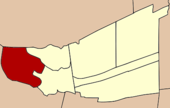
Amphoe Lat Lum Kaeo (Thai: อำเภอ ลาดหลุมแก้ว), ist der westlichste Landkreis (Amphoe - Verwaltungs-Distrikt) der Provinz Pathum Thani in Zentral-Thailand.

Inhaltsverzeichnis

Geographie

Benachbarte Distrikte (von Norden im Uhrezeigersinn): Amphoe Lat Bua Luang der Provinz Ayutthaya, die Amphoe Sam Khok und Mueang Pathum Thani der Provinz Pathum Thani sowie die Amphoe Pak Kret, Bang Bua Thong und Sai Noi der Provinz Nonthaburi.

Geschichte

Der Landkreis wurde am 28. März 1906 eingerichtet.

Verwaltungsgliederung

Amphoe Thanyaburi ist in sieben Gemeinden (Tambon) gegliedert, welche wiederum in 67 Dorfgemeinschaften (Muban) unterteilt sind.

Es gibt zwei Kleinstädte (Thesaban Tambon) im Landkreis:

  • Rahaeng (Thai: เทศบาลตำบลระแหง) besteht aus Teilen des Tambon Rahaeng,
  • Khlong Phra Udom (Thai: เทศบาลตำบลคลองพระอุดม) besteht aus dem gesamten Tambon Khlong Phra Udom.

Es gibt weiterhin sechs Tambon Administrative Organizations (TAO, องค์การบริหารส่วนตำบล - Verwaltungs-Organisationen).

Nr. Name Thai Muban     
1. Rahaeng ระแหง 12
2. Lat Lum Kaeo ลาดหลุมแก้ว 07
3. Khu Bang Luang คูบางหลวง 12
4. Khu Khwang คูขวาง 05
5. Khlong Phra Udom คลองพระอุดม 13
6. Bo Ngoen บ่อเงิน 07
7. Na Mai หน้าไม้ 11

Weblinks


14.037222222222100.404722222227Koordinaten: 14° 2′ N, 100° 24′ O


Wikimedia Foundation.

Игры ⚽ Нужно решить контрольную?

Schlagen Sie auch in anderen Wörterbüchern nach:

  • Lat Lum Kaeo — Original name in latin Lat Lum Kaeo Name in other language Amphoe Lat Hlumkeo, Amphoe Lat Lum Kaeo, Amphoe Rahaeng, Ban Rahaeng (1), Lat Lum Kaeo State code TH Continent/City Asia/Bangkok longitude 14.03728 latitude 100.40486 altitude 7… …   Cities with a population over 1000 database

  • Amphoe Lat Lum Kaeo — Lat Lum Kaeo ลาดหลุมแก้ว Provinz: Pathum Thani Fläche: 183,12 km² Einwohner: 52.995 (2008) Bev.dichte: 261 E./km² PLZ: 12 …   Deutsch Wikipedia

  • Amphoe Lat Lum Kaeo — Infobox Amphoe name=Lat Lum Kaeo thai=ลาดหลุมแก้ว province=Pathum Thani capital=Rahaeng coordinates=coord|14|2|14|N|100|24|17|E|type:adm2nd region:TH area=183.12 population=47,713 population as of=2005 density=261 postal code=12140 geocode=1305… …   Wikipedia

  • Amphoe Lat Lum Kaeo — Admin ASC 2 Code Orig. name Amphoe Lat Lum Kaeo Country and Admin Code TH.39.1609120 TH …   World countries Adminstrative division ASC I-II

  • Lat Bua Luang — ลาดบัวหลวง Provinz: Ayutthaya Fläche: 199,9 km² Einwohner: 36.186 (2000) Bev.dichte: 181,0 E./km² PLZ: 13230 …   Deutsch Wikipedia

  • Amphoe Lat Bua Luang — Lat Bua Luang ลาดบัวหลวง Provinz: Ayutthaya Fläche: 199,9 km² Einwohner: 36.186 (2000) Bev.dichte: 181,0 E./km² PLZ: 13230 …   Deutsch Wikipedia

  • Amphoe Lat Bua Luang — Infobox Amphoe thai=ลาดบัวหลวง name=Lat Bua Luang province=Ayutthaya coordinates=coord|14|9|57|N|100|18|27|E|type:adm2nd region:TH area=199.9 population=36,186 population as of=2000 density=181.0 capital= location= postal code=13230… …   Wikipedia

  • Sam Khok — สามโคก Provinz: Pathum Thani Fläche: 94,967 km² Einwohner: 48.927 (2005) Bev.dichte: 515 E./km² PLZ: 12160 …   Deutsch Wikipedia

  • Liste des amphoe — Ceci est la liste des districts (amphoe) de Thaïlande, triés par province. Sommaire 1 Amnat Charoen 2 Ang Thong 3 Bangkok 4 Buriram …   Wikipédia en Français

  • List of districts of Thailand — The is a list of districts ( amphoe ) of Thailand, sorted by province =Amnat Charoen= Mueang Amnat Charoen Chanuman Pathum Ratchawongsa Phana Senangkhanikhom Hua Taphan Lue Amnat =Ang Thong= Mueang Ang Thong Chaiyo Pa Mok Pho Thong Sawaeng Ha… …   Wikipedia

Share the article and excerpts

Direct link
Do a right-click on the link above
and select “Copy Link”