- Letchworth State Park
-
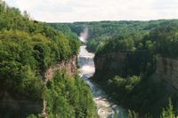 "Ska-ga-dee" - der Mittlere Wasserfall
Der Letchworth State Park liegt im Westen des US-Bundesstaates New York, etwa 55 km südlich der Stadt Rochester. Er erstreckt sich in Nordost-Südwestrichtung über eine Länge von etwa 24 km beidseits des Genesee River und umfasst eine Fläche von fast 60 km². Drei Wasserfälle im Süden des Parks - Oberer, Mittlerer und Unterer Fall - und die bis zu 200 m hohen Steilufer haben diesem Teil des Parks den Namen Grand Canyon of the East eingetragen. Der Mittlere Fall hat eine Höhe von über 30 m und ist nach einer alten Seneca - Legende so wundervoll, dass selbst die Sonne jeden Mittag im Zenit stehen bleibt, um ihn zu bewundern. Etwas flussaufwärts von "Ska-ga-dee", wie der Mittlere Fall von den Seneca genannt wird, überspannt in atemberaubender Höhe das Portage Viadukt der Erie Lackawanna Eisenbahnlinie die Schlucht.
Daneben gibt es im Park noch ungefähr 50 weitere kleinere Wasserfälle, darunter auch an einem kleinen Nebenfluss den "Inspiration Fall", den mit 107 m Fallhöhe tiefsten Wasserfall des Bundesstaates New York.
Der Park geht auf ein Grundstück um das Glen Iris Gasthaus zurück, das William Pryor Letchworth 1859 in der Nähe des Mittleren Falls erwarb und in den folgenden Jahren vergrößerte. 1898 eröffnete er neben dem Gasthaus ein naturkundliches Museum. 1907 übertrug er den Park dem Staate New York. Der Park, überwiegend Laubwald, ist dank seiner zahlreichen Wanderwege ein beliebtes Ausflugsziel.
Weblinks
-
 Commons: Letchworth State Park – Sammlung von Bildern, Videos und Audiodateien
 - Offizielle Seite des Parks (englisch)
- Nützliche Infos zum Park (englisch)
- Letchworth State Park im Geographic Names Information System des United States Geological Survey
42.582777777778-78.043333333333Koordinaten: 42° 34′ 58″ N, 78° 2′ 36″ WKategorien:- State Park in New York
- Geographie (New York)
-

Wikimedia Foundation.