Manilaid

Manilaid

Vorlage:Infobox Insel/Wartung/Höhe fehlt

Manilaid
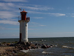
Leuchtturm von Manilaid
Gewässer Rigaischer Meerbusen
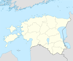
Geographische Lage 58° 12′ 49″ N, 24° 7′ 16″ O58.21361111111124.121111111111Koordinaten: 58° 12′ 49″ N, 24° 7′ 16″ O
Manilaid (Estland)
Manilaid
Fläche 1,87 km²
Einwohner 49 (2006)
26 Einw./km²
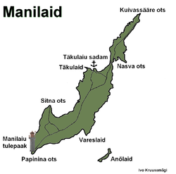
Manilaiu kaart
Manilaiu kaart

Manilaid (auch: Manija, deutsch: Manja) ist eine estnische Ostsee-Insel. Sie liegt in der Rigaer Bucht zwischen der Halbinsel Tõstamaa und der estnischen Insel Kihnu.

Manilaid liegt etwa einen Kilometer vom Festland entfernt. Die Größe der Insel beträgt 1,87 km². In der Nähe finden sich die Eilande Annilaid (auch Anõlaid) mit einer Größe von 0,03 km² und Munalaid. Vom Hafen Lemsi auf Kihnu aus gibt es eine regelmäßige Fährverbindung zu den Inseln. Die Inseln gehören verwaltungsmäßig zur Gemeinde Tõstamaa im Kreis Pärnu.

Manilaid wurde erstmals 1560 als Holm Maune urkundlich erwähnt. Bis 1933 war die Insel unbewohnt, bevor Esten aus Kihnu auf der Insel siedelten. Heute leben dort dauerhaft 49 Menschen (Stand 2006) in Manija. 2005 erhielt die gesamte Ortschaft Wireless LAN.

Auf der Halbinsel Papina befindet sich der acht Meter hohe Leuchtturm der Insel.

Weblinks


Wikimedia Foundation.

Игры ⚽ Поможем написать курсовую

Schlagen Sie auch in anderen Wörterbüchern nach:

  • Manilaid — Manija   village   Manilaid in the Gulf of Riga. Coord …   Wikipedia

  • Manilaid — Sp Mãnilaidas Ap Manilaid L s. Baltijos j., Estija …   Pasaulio vietovardžiai. Internetinė duomenų bazė

  • Annilaid — Lage von Manilaid Leuchtturm von Manilaid Manilaid ist eine estnische Ostsee Insel. Sie liegt in der Rigaer Bucht zwischen der Halbinsel Tõstamaa und der estnische …   Deutsch Wikipedia

  • Manija — Lage von Manilaid Leuchtturm von Manilaid Manilaid ist eine estnische Ostsee Insel. Sie liegt in der Rigaer Bucht zwischen der Halbinsel Tõstamaa und der estnische …   Deutsch Wikipedia

  • Munalaid — Lage von Manilaid Leuchtturm von Manilaid Manilaid ist eine estnische Ostsee Insel. Sie liegt in der Rigaer Bucht zwischen der Halbinsel Tõstamaa und der estnische …   Deutsch Wikipedia

  • Saaremaa — This article is about the island. For the village in Võru County, see Saaremaa, Võru County. Saaremaa …   Wikipedia

  • Hiiumaa — Tahkuna peninsula is the most northern part of Hiiumaa Geography …   Wikipedia

  • Vormsi — Estonia s fourth largest island, Vormsi (German: Worms, Swedish: Ormsö), is located between Hiiumaa and the mainland with a total area of 93 square kilometers. It is part of a rural municipality Vormsi Parish. From mainland, Vormsi is separated… …   Wikipedia

  • Muhu — (German: Mohn/Moon; in Estonian also called Muhumaa), is an island in the Baltic Sea. With an area of 198 km² it is the third largest island belonging to Estonia, after Saaremaa and Hiiumaa. Together with neighbouring smaller islands of… …   Wikipedia

  • Osmussaar — Limestone cliff on the east coast of Osmussaar Geography Location …   Wikipedia

Share the article and excerpts

Direct link
Do a right-click on the link above
and select “Copy Link”