Margosatubig

Margosatubig
Municipality of Margosatubig
Lage von Margosatubig in der Provinz Zamboanga del Sur
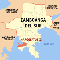
Karte
Basisdaten
Bezirk: Zamboanga Peninsula
Provinz: Zamboanga del Sur
Barangays: 17
Distrikt: 2. Distrikt von Zamboanga del Sur
PSGC: 097317000
Einkommensklasse: 4. Einkommensklasse
Haushalte: 6560
Zensus 1. Mai 2000
Einwohnerzahl: 34.939
Zensus 1. August 2007
Koordinaten: 7° 35′ N, 123° 10′ O7.5833333333333123.16666666667Koordinaten: 7° 35′ N, 123° 10′ O
Postleitzahl: 7035
Bürgermeister: George M. Minor
Offizielle Webpräsenz: Margosatubig
Geographische Lage auf den Philippinen
Margosatubig (Philippinen)
Margosatubig
Margosatubig

Margosatubig ist eine philippinische Stadtgemeinde in der Provinz Zamboanga del Sur. Nach dem Zensus vom 1. Mai 2000 hat sie 34.461 Einwohner in 6560 Haushalten.

Baranggays

Margosatubig ist politisch in 17 Baranggays unterteilt.

  • Balintawakan
  • Bularongan
  • Digon
  • Guinimanan
  • Igat Island
  • Josefina
  • Kalian
  • Kolot
  • Limamawan
  • Lumbog
  • Magahis
  • Poblacion
  • Sagua
  • Talanusa
  • Tiguian
  • Tulapoc

Wikimedia Foundation.

Игры ⚽ Поможем написать реферат

Schlagen Sie auch in anderen Wörterbüchern nach:

  • Margosatubig — Original name in latin Margosatubig Name in other language Fort Margosatubig, Margosatubig State code PH Continent/City Asia/Manila longitude 7.5777 latitude 123.1658 altitude 8 Population 14605 Date 2011 07 31 …   Cities with a population over 1000 database

  • Margosatubig, Zamboanga del Sur — Margosatubig Margos   Municipality   Map of Zam …   Wikipedia

  • Malangas, Zamboanga Sibugay — Municipality of Malangas …   Wikipedia

  • Dimataling, Zamboanga del Sur — Dimataling   Municipality   Map of Zamboanga del Sur showing the location of Dimataling …   Wikipedia

  • Pax high school — A private catholic secondary school in the town of Margosatubig, in the province of Zamboanga del Sur, Philippines founded by Fr. Rosalino Pascua, S.J. in 1963. The school is known for its quality education and for producing competitive and… …   Wikipedia

  • PH-ZAS — Lage von Zamboanga del Sur Die Provinz Zamboanga del Sur besetzt die südöstliche Ecke der Halbinsel Zamboanga. Diese ist ein Ausläufer der Insel Mindanao, der größten Insel im Süden der Philippinen. Die Hauptstadt der Provinz ist Pagadian City.… …   Deutsch Wikipedia

  • Medina College-Pagadian — Pamantasan ng Medina Pagadian Motto The New and Bright Horizon in Modern Education Established June 1999 …   Wikipedia

  • Dinas, Zamboanga del Sur — Dinas   Municipality   Coordinates …   Wikipedia

  • Dumalinao, Zamboanga del Sur — Dumalinao   Municipality   Map of Zamboanga del Sur showing the location of Dumalinao …   Wikipedia

  • Dumingag, Zamboanga del Sur — Dumingag   Municipality   Map of Zamboanga del Sur showing the location of Dumingag …   Wikipedia

Share the article and excerpts

Direct link
Do a right-click on the link above
and select “Copy Link”