Mirpurkhas

Mirpurkhas
Mirpur Khas (Pakistan)
DMS
Mirpur Khas
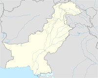
Mirpur Khas
Lage von Mirpur Khas in Pakistan

Mirpur Khas (oft auch zusammen geschrieben: Mirpurkhas, Urdu/Sindhi: میرپور خاص) ist mit einer Bevölkerung von 124.371 (1981) die viertgrößte Stadt in der Provinz Sindh, Pakistan. Die Stadt ist berühmt wegen der über 200 verschieden Arten von Mangos, die hier wachsen.

Lage

Die Stadt liegt am Let Wah Canal bei den Koordinaten 25° 24' N und 69° O. Sie ist per Eisenbahnschienen mit Hyderabad verbunden und per Hauptstraße mit Umarkot. Weitere in der Nähe liegende Nachbarn sind die Wüste Thar, Karatschi und Hyderabad.

Mirpur Khas liegt nicht weit von Indien und war auch eine der ersten Städte, die nach dem Entstehen des Landes Pakistan Flüchtlinge aufnahm. Die indische Grenze liegt 170 Kilometer entfernt.

Die Stadt hat zahlreiche Shopping Center und Basare, zu denen das Baldia Shopping Center, der Shahi Bazaar und Khisakpura gehören.

25.51794444444469.0126111111117Koordinaten: 25° 31′ N, 69° 1′ O


Wikimedia Foundation.

Игры ⚽ Поможем решить контрольную работу

Schlagen Sie auch in anderen Wörterbüchern nach:

  • Mirpur Khas — Mirpur Khas …   Wikipedia

  • Mirpur Khas District —   District   Location of Mirpurkhas in Sindh province Country …   Wikipedia

  • Digri — Digri …   Wikipedia

  • Tharparkar District — Infobox Pakistan district district = Tharparkar District area = 19,638 population = 955,812 pop year = 1998 density = established = nazim = Arbab Anwar Jabbar naib nazim = Abdul Karim languages = website = caption=Tharparkar ( sd. ٿرپارڪر) ( ur.… …   Wikipedia

  • District Government Umerkot — Umerkot District was initially created in 1993, but later on, due to some political reasons, it was abolished and merged with district Mirpurkhas in December 2000. However, after four years, it was restored in December 2004. District Government… …   Wikipedia

  • Muslim Rajput clans — Here is a brief description of the major Muslim Rajput clans by location. The information is obtained from the various district gazetteers written during the period of British rule over India. Major languages spoken by the Muslim Rajputs of… …   Wikipedia

  • Chitorri — is the historic ancestral graveyard of the Talpur Mirs of Mirpurkhas, Sindh. The sandstone tombs built by Talpur rulers over the graves of their elders are the finest examples of Sindh s architecture prevalent in 17th and 18th century.[citation… …   Wikipedia

  • Tando Jan Mohammad — is Taluka digri in Mirpurkhas Sindh Pakistan. It is situated near district Mirpurkhas round about 60 km away from the Mirpurkhas city. The name Tando Jan Mohammad is being derived from the Ex.Ruler and the city owner Mir. Sakhi Jan Mohammad, who… …   Wikipedia

  • List of prisons — This page provides a list of prisons by country. Algeria*Serkadji prisonAustralia: For prisons in Australia, see list of Australian Prisons and Detention Centres Australian Capital Territory * Belconnen Remand Centre * Periodic Detention Centre… …   Wikipedia

  • Muhajir (Pakistan) — See Muhajir page for all Muhajir groups in the world Muhajir or Panahgir ( ur. مہاجر) is a diverse term used to describe the Muslim refugees who migrated to Pakistan after the independence in 1947. Traditionally meaning the Muslim refugees who… …   Wikipedia

Share the article and excerpts

Direct link
Do a right-click on the link above
and select “Copy Link”