Arizona State Route 389

Arizona State Route 389
Straßenschild der Arizona State Route 389
Karte
Karte der Arizona State Route 389
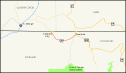
Basisdaten
Gesamtlänge:  32.60 mi/52.46 km
Anfangspunkt:  Utah SR 59.svg UT 59 bei Colorado City
Endpunkt:  US 89A.svg US 89A bei Fredonia
County:  Mohave County

Die Arizona State Route 389 ist eine State Route im Norden US-Bundesstaat Arizona. Sie erschließt den Arizona Strip, das durch den Grand Canyon vom Rest Arizonas abgetrennte nordwestlichste Stück des Bundesstaates.

Der Highway beginnt bei Colorado City an der Utah State Route 59 an der Grenze zu Utah, passiert die Kaibab Paiute Indian Reservation mit dem Pipe Spring National Monument und dem Ort Kaibab und endet nach der Überquerung des kleinen Kanab Creek am U.S. Highway 89A bei Fredonia.

Siehe auch

Weblinks


Wikimedia Foundation.

Игры ⚽ Поможем написать реферат

Schlagen Sie auch in anderen Wörterbüchern nach:

  • Arizona State Route 389 — Infobox road marker state=AZ highway name= name notes= type=state route=389 alternate name= maint= length mi=32.60 length round=2 length ref=cite web |url=http://tpd.az.gov/data/reports/2006SHSLog.pdf |title=2006 ADOT Highway Log |author=Arizona… …   Wikipedia

  • Arizona State Route 387 — Infobox road marker state=AZ highway name= name notes= type=state route=387 alternate name= maint= length mi=15.71 length round=2 length ref=cite web |url=http://tpd.az.gov/data/reports/2006SHSLog.pdf |title=2006 ADOT Highway Log |author=Arizona… …   Wikipedia

  • Arizona State Route 473 — Infobox road marker state=AZ highway name= name notes= type=state route=473 alternate name= maint= length mi=9.91 length round=2 length ref=cite web|url=http://tpd.az.gov/data/reports/2006SHSLog.pdf|title=2006 ADOT Highway Log|publisher=Arizona… …   Wikipedia

  • Utah State Route 59 — Infobox road state=UT type=SR route=59 section=113 maint=UDOT length mi=22.206 length round=3 length ref=cite web | title=State Route 59 Highway reference | publisher=Utah Department of Transportation |… …   Wikipedia

  • Arizona Strip — Der Arizona Strip im Nordwesten Arizonas Ein Seitencanyon im Arizona Strip …   Deutsch Wikipedia

  • Liste der Highways in Arizona — Dies ist eine Aufstellung von State Routes, U.S. Highways und Interstates im US Bundesstaat Arizona, nach Nummern. Inhaltsverzeichnis 1 State Routes 1.1 Gegenwärtige Strecken 1.2 Geplante Strecken 1.3 Außer Die …   Deutsch Wikipedia

  • List of highways numbered 389 — The following highways are numbered 389: Canada Quebec Route 389 Japan Japan National Route 389 United States …   Wikipedia

  • Colorado City (Arizona) — Colorado City Ortseingang von Colorado City Lage im County und in Arizona …   Deutsch Wikipedia

  • Fredonia (Arizona) — Fredonia Lage im Coconino County und in Arizona Basisdaten …   Deutsch Wikipedia

  • Arizona — This article is about the U.S. state of Arizona. For other uses, see Arizona (disambiguation). State of Arizona …   Wikipedia

Share the article and excerpts

Direct link
Do a right-click on the link above
and select “Copy Link”