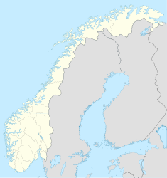
Oppstrynsvatn

Oppstrynsvatn
Oppstrynsvatnet
Geographische Lage: Stryn (Sogn og Fjordane)
Daten
Koordinaten 61° 56′ 6″ N, 6° 55′ 20″ O61.9356.92222222222227Koordinaten: 61° 56′ 6″ N, 6° 55′ 20″ O
Oppstrynsvatnet (Norwegen)
DEC
Oppstrynsvatnet
Höhe über Meeresspiegel 29 m
Fläche 22,87 km²dep1
Volumen  ? km³dep1
Umfang 38,55 kmdep1
Maximale Tiefe 230 mdep1

Oppstrynsvatnet(oder Oppstrynsvatn[1]) ist der Name eines Sees in der Kommune Stryn in der norwegischen Provinz Sogn og Fjordane.

Siehe auch

Einzelnachweise und Fußnoten

  1. Das Suffix "-et" ist die norwegische Form des bestimmten sächlichen Artikels. Daher gibt es die beiden Formen Oppstrynsvatnet und Oppstrynsvatn.

Wikimedia Foundation.

Игры ⚽ Нужно сделать НИР?

Schlagen Sie auch in anderen Wörterbüchern nach:

  • Oppstrynsvatn — Location Stryn (Sogn og Fjordane) Coordinates …   Wikipedia

  • Oppstrynsvatnet — Geographische Lage Stryn (Sogn og Fjordane) Zuflüsse Hjelledøla …   Deutsch Wikipedia

  • Mjøsa — View northwards from Minnesund, Eidsvoll Location Akershus, Hedmark, Oppland Coordinates …   Wikipedia

  • Østensjøvannet — photo: Hans Petter Fjeld Location Oslo Coordinates …   Wikipedia

  • Norsjø — I♥U Norsjø Lake Norsjo in Gvarv Location Skien, Nome, Sauherad (Telemark) Coordinates …   Wikipedia

  • Mørsvikvatnet — Location Sørfold, Nordland Coordinates 67°43′26″N 15°55′5″E …   Wikipedia

  • List of lakes in Norway — Lake Ulvsvann in Skien, Telemark Lake Ovre Sjodal …   Wikipedia

  • Øyeren — Map of Øyeren and surrounds Location …   Wikipedia

  • Blåsjø — Location Bykle, Aust Agder Hjelmeland, Rogaland Suldal, Rogaland Coordinates …   Wikipedia

  • Møsvatn — Storfjorden on Møsvatn in direction west …   Wikipedia

Share the article and excerpts

Direct link
Do a right-click on the link above
and select “Copy Link”