Ovalau

Ovalau
Ovalau
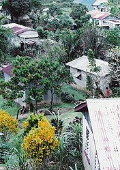
Dorf auf Ovalau
Dorf auf Ovalau
Gewässer Pazifischer Ozean
Inselgruppe Lomaiviti-Inseln (Fidschi-Inseln)
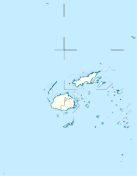
Geographische Lage 17° 41′ S, 178° 47′ O-17.688055555556178.79055555556625Koordinaten: 17° 41′ S, 178° 47′ O
Ovalau (Fidschi)
Ovalau
Länge 14,9 km
Breite 10,0 km
Fläche 102,3 km²
Höchste Erhebung Nadelaiovalau
625 m
Einwohner 9.000
88 Einw./km²
Hauptort Levuka
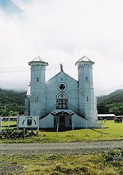
St. John Kirche, Ovalau

Ovalau ist die sechstgrößte Insel Fidschis und Verwaltungssitz der Lomaiviti-Inselgruppe.

Bis zum Jahre 1882 war die Stadt Levuka die Hauptstadt der britischen Kronkolonie Fidschi (englisch: Fiji).

Geographie

Die Landfläche beträgt 102,3 km²,[1] die Insel hat eine Bevölkerung von ca. 9000 Menschen, die in 23 Dörfern und der ehemaligen Hauptstadt Levuka leben. Ovalau ist vulkanischen Ursprungs und hat eine zerklüftete, bergige Topografie. Im Zentrum der Insel, in der Caldera, liegt das Dorf Lovoni, der höchste Gipfel ist der Nadelaiovalau mit 625 Metern Höhe über dem Meer.

Weblinks

 Commons: Ovalau – Sammlung von Bildern, Videos und Audiodateien

Einzelnachweise

  1. UNEP Islands Directory (englisch)

Wikimedia Foundation.

Игры ⚽ Нужно сделать НИР?

Schlagen Sie auch in anderen Wörterbüchern nach:

  • Ovalau — Géographie Pays  Fidji Archipel Lomaiviti Localisation Océan Pacifique …   Wikipédia en Français

  • Ovalau — (pronounced|oβalau) is the sixth largest island in Fiji s Lomaiviti archipelago. Situated at 17.70° South and 178.8° East, (60 km north east from the national capital Suva and 20km off the east coast of Viti Levu), the island is about 13… …   Wikipedia

  • Ovalau — Ovalau, eine der Fidschiinseln (s. d. und Levuka) …   Meyers Großes Konversations-Lexikon

  • Ovalau Island — may refer to Ovalau (Vava u), an island in Tonga Ovalau (Fiji), an island in Fiji This disambiguation page lists articles about distinct geographical locations with the same name. If an internal link …   Wikipedia

  • Ovalau (Vava'u) — Ovalau is an island in Tonga. It is located within the Vava u Group in the far north of the country. Coordinates: 18°45′S 174°05′W / 18.75°S 174.083°W …   Wikipedia

  • Ovalau (Fiji) — For the island in Tonga, see Ovalau (Vava u) . Ovalau (pronounced [oβaˈlau]) is the sixth largest island in Fiji s Lomaiviti Archipelago. Situated at 17.70° South and 178.8° East, (60 km north east from the national capital Suva and… …   Wikipedia

  • Tailevu North Ovalau (Open Constituency, Fiji) — Tailevu North Ovalau Open is an electoral division of Fiji, one of 25 open constituencies elected by universal suffrage (the remaining 46 seats, called communal constituencies, are allocated by ethnicity). Like the other open electorates, it came …   Wikipedia

  • Farebrother-Sullivan Trophy — Le Farebrother Sullivan Trophy est une compétition de rugby à XV des îles Fidji ouverte aux sélections régionales issues des districts du rugby fidjien. Sommaire 1 Historique 2 Résultats 3 Statistiques 3.1 …   Wikipédia en Français

  • Farebrother-sullivan trophy — Le Farebrother Sullivan Trophy est une compétition de rugby à XV des îles Fidji ouverte aux sélections régionales issues des districts du rugby fidjien. Sommaire 1 Historique 2 Résultats 3 Statistiques …   Wikipédia en Français

  • Levuka — is a town on the south east coast of the Fijian island of Ovalau, in Lomaiviti Province, in the Eastern Division of Fiji, of which it is the capital. At the census in 1996, the last to date, Levuka had a population of 3,745, more than a third of… …   Wikipedia

Share the article and excerpts

Direct link
Do a right-click on the link above
and select “Copy Link”