Paget Island

Paget Island
Paget Island
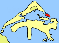
Lage von Paget Island (farblich hervorgehoben) innerhalb der Bermudas
Lage von Paget Island (farblich hervorgehoben)
innerhalb der Bermudas
Gewässer Atlantischer Ozean
Inselgruppe Bermuda
Geographische Lage 32° 22′ 31″ N, 64° 39′ 36″ W32.375277777778-64.6614Koordinaten: 32° 22′ 31″ N, 64° 39′ 36″ W
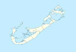
Paget Island (Bermuda)
Paget Island
Länge 650 m
Breite 220 m
Fläche 0,14 km²dep1
Höchste Erhebung 14 m
Einwohner (unbewohnt)

Paget Island ist eine Insel im Nordosten von Bermuda. Sie liegt zwischen Saint George’s Island und Saint David’s Island im atlantischen Zugang zur Bucht Saint George’s Harbour.

Der Nordwestküste unmittelbar vorgelagert sind die unbewohnten Eilande Higgs Island sowie Horseshoe Island; etwa 250 Meter vor der Südküste der Insel liegt Smith’s Island.

Paget Island gehört zum Verwaltungsgebiet Saint George’s Parish, ist etwa 650 Meter lang und maximal 220 Meter breit. Auf der dicht bewaldeten, knapp 0,14 km² großen Insel befinden sich ein paar kleine Wirtschaftsgebäude sowie die Überreste der um 1820 erbauten Festungsanlage Fort Cunningham.

Die Insel ist nach dem englischen Aristokraten William Paget benannt.

Siehe auch

Weblinks


Wikimedia Foundation.

Игры ⚽ Поможем написать курсовую

Schlagen Sie auch in anderen Wörterbüchern nach:

  • Paget Island, Bermuda — Paget Island is part of the chain which makes up Bermuda. It is located in St. George s Parish, in the northeast of the territory.The 36 acre (14.5 hectare) island is located at the northern entrance to St. George s Harbor, east of the town of St …   Wikipedia

  • Paget — ist der Familienname folgender Personen: Charles Octavius Paget (1846–1909), österreichischer Industrieller Debra Paget (* 1933), US amerikanische Schauspielerin Frederick Paget (1805–1867), englisch österreichischer Industrieller Henry Paget,… …   Deutsch Wikipedia

  • Paget Parish, Bermuda — Paget Parish is one of the nine parishes of Bermuda. It is named for William Paget, 4th Baron Paget de Beaudesert (1572 1629).It is located in the central south of the island chain, immediately south of Hamilton Harbor on the main island. It is… …   Wikipedia

  • Horseshoe Island — Lage von Horseshoe Island (rot eingekreist) innerhalb der Bermudas Gewässer …   Deutsch Wikipedia

  • Higgs Island — Lage von Higgs Island (rot eingekreist) innerhalb der Bermudas Gewässer At …   Deutsch Wikipedia

  • Smith’s Island — Smith s Island Lage von Smith s Island (rot markiert) innerhalb der Bermudas Gewässer …   Deutsch Wikipedia

  • Smith's Island, Bermuda — Smith s Island is part of the chain which makes up Bermuda. It is located in St. George s Parish, in the northeast of the territory.The 61 acre (24.5 hectare) island is located close to the northern entrance to St. George s Harbour, east of the… …   Wikipedia

  • Mount Paget — Location of Mt. Paget Elevation 2,935 m (9,629 ft)  …   Wikipedia

  • Hinson's Island — Hinson’s Island Karte des Paget Parish (Hinson’s Island in der Bildmitte links) Gewässer Atlantischer Ozean Inselgr …   Deutsch Wikipedia

  • Debra Paget — with John Derek from the trailer for The Ten Commandments (1956) Born Debralee Griffin August 19, 1933 ( …   Wikipedia

Share the article and excerpts

Direct link
Do a right-click on the link above
and select “Copy Link”