Astove Island

Astove Island
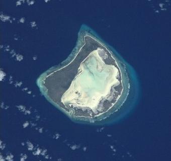
Satellitenbild der Astove-Insel

Astove (engl. Astove Island) ist eine kleine Insel im Indischen Ozean, nördlich von Madagaskar gelegen, die zur Inselrepublik der Seychellen gehört. Sie liegt etwa 38 Kilometer südlich des Cosmoledo-Atolls und gehört zur Aldabra-Gruppe, welche zu den Outer Islands der Seychellen gezählt wird. Gemeinsam mit dem Cosmoledo-Atoll wird die Astove-Insel gelegentlich als die „Cosmoledo-Gruppe“ bezeichnet.

Die Astove-Insel ist etwa 6 km lang, 4 km breit und weist eine Landfläche von knapp 5 km² auf. Bei Astove handelt es sich um ein Gehobenes Atoll, bei welchem der gehobene Saumriff die Lagune fast vollständig vom Meer getrennt hat. Die Fläche der Lagune auf Astove beträgt 9,5 km². Die Insel ist heute unbewohnt, an der Westküste liegt noch die in den 1980er Jahren verlassene Siedlung.

Der intensive Abbau von Guano in der Vergangenheit hat die Oberfläche der Insel verödet, nur wenige Bäume, beispielsweise Pisonia, wachsen auf ihr. Eingeführte Ratten und Hausschweine haben die Populationen der Seevögel dezimiert, allerdings kommen auf Astove auch vier Arten Landvögel vor, beispielsweise der Schildrabe (Corvus albus).

-10.08666666666747.7408333333337Koordinaten: 10° 5′ S, 47° 44′ O


Wikimedia Foundation.

Игры ⚽ Нужен реферат?

Schlagen Sie auch in anderen Wörterbüchern nach:

  • Astove Island — is part of the Aldabra Group of the Seychelles. It is 38 km SSE of Cosmoledo Atoll, located at (coord|10|06|S|47|45|E|). It is a raised coral island of most peculiar form: a single stretch of land, more than 1 km (nearly one mile) at the widest,… …   Wikipedia

  • Astove — Géographie Pays   …   Wikipédia en Français

  • Astove-Insel — Vorlage:Infobox Insel/Wartung/Höhe fehlt Astove NASA Bild der Astove Insel Gewässer Indischer Ozean …   Deutsch Wikipedia

  • Astove — Satellitenbild der Astove Insel Astove (engl. Astove Island) ist eine kleine Insel im Indischen Ozean, nördlich von Madagaskar gelegen, die zur Inselrepublik der Seychellen gehört. Sie liegt etwa 38 Kilometer südlich des Cosmoledo Atolls und… …   Deutsch Wikipedia

  • Île Astove — Astove Island (en) Image satellite de l île Astove. Géographie Pays …   Wikipédia en Français

  • Aldabra Group — The Aldabra Group are part of the Outer Islands of the Seychelles, lying in the southwest of the island nation, 1000 kilometres from the capital, Victoria, on Mahé Island.The total land area of the Aldabra Group is 175.91 km².Islands in the… …   Wikipedia

  • Астов — фр. Île Astove …   Википедия

  • Cosmoledo — Seychelles Overview Map Cosmoledo Atoll from the air …   Wikipedia

  • List of islands of Africa — This is a list of islands of Africa.Cape Verde*Boa Vista *Branco *Brava *Fogo *Maio *Raso *Sal *Santa Luzia *Santo Antão *São Nicolau *São Tiago *São VicenteDjibouti*Maskali Island *Moucha Islands *Sept Freres, DjiboutiEquatorial Guinea*Annobón… …   Wikipedia

  • Geography of Seychelles — Map of Seychelles The Seychelles is a small island nation located in the Indian Ocean northeast of Madagascar and about 1,600 km (994 mi) east of Kenya. Seychelles lies between approximately 4ºS and 10ºS and 46ºE and 54ºE. The nation is …   Wikipedia

Share the article and excerpts

Direct link
Do a right-click on the link above
and select “Copy Link”