Palerang Council

Palerang Council
Palerang
Australia-Map-NSW-LGA-Palerang.png
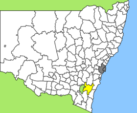
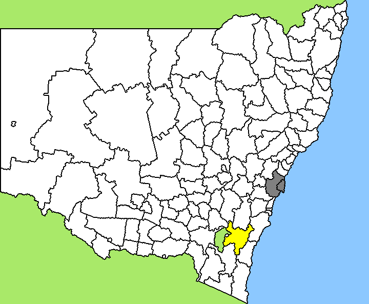
Lage des Palerang Council in New South Wales
Gliederung
Staat: Australien Australien
Bundesstaat: Flag of New South Wales.svg New South Wales
Verwaltungssitz: Bungendore
Daten und Zahlen
Fläche: 5.134 km²
Einwohner: 12.318 (2006) [1]
Bevölkerungsdichte: 2,4 Einwohner je km²
-35.416666666667149.68333333333

Palerang ist ein lokales Verwaltungsgebiet (LGA) im australischen Bundesstaat New South Wales. Das Gebiet ist 5.134 km² groß und hat etwa 12.300 Einwohner. Bis 2005 hieß die LGA noch Eastern Capital City Regional.

Palerang liegt im Südosten des Staates und grenzt im Westen an das Australian Capital Territory um die Hauptstadt Canberra. Das Gebiet umfasst 65 Ortsteile und Ortschaften, darunter Bungendore, Braidwood, Captains Flat, Araluen, Mongarlowe, Majors Creek, Nerriga und Teile von Carwoola und Sutton. Der Verwaltungssitz des Councils befindet sich in der Stadt Bungendore im Nordosten der LGA, wo etwa 2.200 Einwohner leben.

Verwaltung

Der Council von Palerang hat neun Mitglieder, die von den Bewohnern der LGA gewählt werden. Palerang ist nicht in Bezirke untergliedert. Aus dem Kreis der Councillor rekrutiert sich auch der Mayor (Bürgermeister) des Councils.

Weblinks

Einzelnachweise

  1. Australian Bureau of Statistics (25. Oktober 2007): Palerang (A) (Local Government Area) (Englisch). 2006 Census QuickStats. Abgerufen am 6. April 2010.

Wikimedia Foundation.

Игры ⚽ Поможем написать реферат

Schlagen Sie auch in anderen Wörterbüchern nach:

  • Palerang Council — Infobox Australian Place | type = lga name = Palerang state = nsw caption = Location in NSW pop = 11,470 cite web publisher = Australian Bureau of Statistics title=Regional Population Growth, Australia, 2004 05 url =… …   Wikipedia

  • Goulburn Mulwaree Council — Infobox Australian Place | type = lga name = Goulburn Mulwaree state = nsw caption = Location in NSW pop = 27,112 cite web publisher = Australian Bureau of Statistics title=Regional Population Growth, Australia, 2004 05 url =… …   Wikipedia

  • Marrickville Council — New South Wales Population: 78,271(2009) …   Wikipedia

  • Burwood Council — New South Wales Population: 33,803(2009) …   Wikipedia

  • Manly Council — New South Wales Population: 40 …   Wikipedia

  • North Sydney Council — New South Wales Population: 63,914(2009) …   Wikipedia

  • Clarence Valley Council — Clarence Valley New South Wales Location in New South Wales Population …   Wikipedia

  • Deniliquin Council — New South Wales Population: 7,693(2009) …   Wikipedia

  • Yass Valley Council — Infobox Australian Place | type = lga name = Yass Valley state = nsw caption = Location in NSW pop = 9,675 [ cite web publisher = Australian Bureau of Statistics title=Regional Population Growth, Australia, 2004 05 url =… …   Wikipedia

  • Eurobodalla Shire Council — Infobox Australian Place | type = lga name = Eurobodalla Shire state = nsw caption = Offices of the Eurobodalla Shire council at Moruya pop = 36,389 [cite web publisher = Australian Bureau of Statistics title=Regional Population Growth, Australia …   Wikipedia

Share the article and excerpts

Direct link
Do a right-click on the link above
and select “Copy Link”