Astrolabe Island

Astrolabe Island

Vorlage:Infobox Insel/Wartung/Fläche fehltVorlage:Infobox Insel/Wartung/Höhe fehlt

Astrolabe Island
Karte von Grahamland, Astrolabe Island ist bei Nummer 15
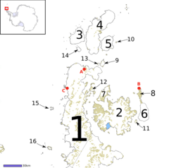
Gewässer Bransfieldstraße (Südlicher Ozean)
Geographische Lage 63° 19′ 0″ S, 58° 41′ 0″ W-63.316666666667-58.683333333333Koordinaten: 63° 19′ 0″ S, 58° 41′ 0″ W
Astrolabe Island (Antarktische Halbinsel)
Astrolabe Island
Länge 4,8 km
Einwohner (unbewohnt)

Astrolabe Island ist eine in der Bransfieldstraße westlich der Trinity Peninsula gelegene Insel. Sie ist unbewohnt, hat eine Länge von etwa 4,8 km und beherbergt verschiedene Pinguinarten (u. a. Esels- und Adeliepinguine).[1]

Entdeckt und benannt wurde die Insel während der ersten französischen Antarktisexpedition (1837–1840) unter Jules Dumont d’Urville. Eines seiner Schiffe hieß Jean-François de La Pérouse. Dieses Schiff war auch namensgebend für die Insel.[2]

Einzelnachweise

  1. http://pinguinkamera-antarktis.blogspot.com/search/label/Astrolabe%20Island
  2. Astrolabe Island im Australian Antarctic Data Centre

Wikimedia Foundation.

Игры ⚽ Поможем написать курсовую

Schlagen Sie auch in anderen Wörterbüchern nach:

  • Astrolabe Island — (coord|63|17|S|58|40|W|) is an island 3 miles (4.8 km) long, lying in Bransfield Strait 14 miles (22 km) northwest of Cape Ducorps, Trinity Peninsula. Discovered by the French expedition, 1837 40, under Captain Jules Dumont d Urville, and named… …   Wikipedia

  • Astrolabe Needle — (coord|64|8|S|62|36|W|) is a conspicuous monolith rising 50 m above sea level south of Claude Point, Brabant Island, in the Palmer Archipelago. Discovered by the French Antarctic Expedition under Charcot, 1903 05, and named after the Astrolabe ,… …   Wikipedia

  • Astrolabe Reef — 37.5405176.427 Koordinaten: 37° 32′ S, 176° 26′ O …   Deutsch Wikipedia

  • French ship Astrolabe (1817) — The Astrolabe was a horse barge converted to an exploration ship of the French Navy. She is famous for her travels with Jules Dumont d Urville. The Astrolabe Subglacial Basin in Antarctica bears her name, as do the Astrolabe Glacier, the… …   Wikipedia

  • Dobrowolski Island — (64°36′S 62°55′W / 64.6°S 62.917°W / 64.6; 62.917) is a small island which lies close to the east coast of Anvers Island, 3 nautical miles (6 km) southwest of …   Wikipedia

  • Great Astrolabe Reef — The Great Astrolabe Reef is in Fiji and surrounds the fourth largest island, Kadavu Island, which is approximately 65 km in length. Kadavu Island is approximately 100 km south of Viti Levu, the main island of Fiji. The Great Astrolabe… …   Wikipedia

  • USS Astrolabe Bay (AVG-60) — USS Guadalcanal (CVE 60) 1944 Geschichte Bestellung 1942 Kiellegung 5. Januar 1943 …   Deutsch Wikipedia

  • Andersson Island — Andersson Island, once known as Rosamel Island, is an island located at the eastern end of the Tabarin Peninsula, Antarctica. It is one of several islands around the peninsula known as Graham Land, which is closer to South America than any other… …   Wikipedia

  • Ono Island (Fiji) — This article is about Ono Island in Fiji. For Ono Island in Alabama, see Ono Island (Alabama). Ono Island is a member of the Kadavu Group, an outlier to Kadavu Island, to the south of Viti Levu, one of Fiji s two main islands. It is separated… …   Wikipedia

  • Mai Dive' Astrolabe Reef Resort — (Остров Оно,Фиджи) Категория отеля: 4 звездочный отель Адрес: Nu …   Каталог отелей

Share the article and excerpts

Direct link
Do a right-click on the link above
and select “Copy Link”