Pandan Island

Pandan Island

Vorlage:Infobox Insel/Wartung/Höhe fehlt

Pandan Island
Strand auf Pandan
Strand auf Pandan
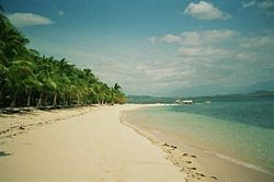
Gewässer Südchinesisches Meer
Inselgruppe Philippinen
Geographische Lage 12° 51′ 28″ N, 120° 45′ 0″ O12.857777777778120.75Koordinaten: 12° 51′ 28″ N, 120° 45′ 0″ O
Pandan Island (Philippinen)
Pandan Island
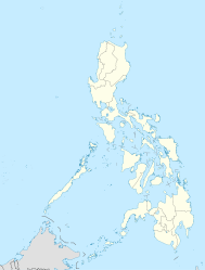
Fläche 0,2 km²

Pandan Island ist eine 20 ha große Insel in den Philippinen. Sie ist seit 1994 als geschütztes Gebiet ausgewiesen, 2 km vor der Küste der Frachthafenstadt Sablayan. Die etwa tropfenförmige Insel wurde nach der hier häufig vorkommenden Pandan-Palme benannt. Von ihr gibt es etliche Unterarten, wobei die Früchte der Pandanus amaryllifolius u.a. in Getränke- und Parfümindustrie verwendet werden und auch Gefallen bei den Flugfüchsen finden. Daher stammt auch der malaiische Name: Pandan ~ Duft, Geruch.

Bekannt ist die Insel (mit Unterkünften in Bambusbungalows) für ihren schönen Sandstrand und ein umlaufendes nahes Riff, das bei Schnorchlern und Tauchern beliebt ist. Sie können von hier aus auch das weltbekannte Apo-Riff anfahren. Begrenzte Unterkünfte in der mittleren Kategorie sind vorhanden. (Siehe Weblinks.)

Weblinks


Wikimedia Foundation.

Игры ⚽ Поможем написать реферат

Schlagen Sie auch in anderen Wörterbüchern nach:

  • Pandan Primary School — was situated in Teban Gardens, Singapore. The school was established in 1981 and closed in 2007. With effect of 1 January 2008, Pandan Primary School was merged with Fuhua Primary School.The principal of the school was Mdm. Tan May Ling who was… …   Wikipedia

  • Pandan Gardens — SG neighbourhood image englishname=Pandan Gardens chinesename = 班丹花园 pinyin = ban1 dan1 hua1 yuan2 malayname=Taman PandanPandan Gardens (population: approx 19,000) is a residential neighbourhood which is part of Jurong East New Town in the West… …   Wikipedia

  • Selat Pandan — (or Pandan Strait) is a strait south of Singapore s main island. It separates the man made Jurong Island from the Southern Islands. It has a depth of approximately 15 m. [ [http://www.lethagencies.com/port.asp?port=SINGASSI link=berths Leth… …   Wikipedia

  • Lankayan Island — is a tropical resort island in the Sulu Sea of Malaysia, Sandakan and 15km from Sabah. [http://www.starfish.ch/dive/Lankayan.html Diving in Lankayan, Sabah, Borneo, Malaysia: dive sites, how to get there, photos (Zubi) ] ] Lankayan Island has… …   Wikipedia

  • Catanduanes (island) — Infobox Islands name = Catanduanes image caption = locator native name = native name link = location = South East Asia coordinates =coord|13|48|N|124|16|E|region:PH type:isle archipelago = Philippine Islands area = 1,511.50 km² rank = highest… …   Wikipedia

  • USS Nautilus (SS-168) — USS Nautilus (SF 9/SS 168), a sclass|Narwhal|submarine and one of the V boats , was the fifth ship of the United States Navy to bear that popular ship s name. She was originally named and designated V 6 (SF 9), but was redesignated and given hull …   Wikipedia

  • Mindoro — Lage der Insel Gewässer Pazifischer Ozean Inselgruppe …   Deutsch Wikipedia

  • Subic Seaplane — Subic Seaplane, Inc. is a non schedule charter airline based in Subic Bay in the Philippines. It provides business, sightseeing, and emergency services.DestinationsSubic Seaplane offers charter flights to the following destinations… …   Wikipedia

  • Apo-Riff — …   Deutsch Wikipedia

  • Sablayan — Municipality of Sablayan Lage von Sablayan in der Provinz Occidental Mindoro Basisdaten Bezirk …   Deutsch Wikipedia

Share the article and excerpts

Direct link
Do a right-click on the link above
and select “Copy Link”