Piako River

Piako River
Piako River

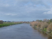
Der Piako River ist ein südlich des Hauraki Gulf auf der Nordinsel Neuseelands gelegener Fluss. Er ist zusammen mit dem Waihou River einer der wichtigsten Flüsse, die das Schwemmland der Hauraki Plains am Südende des Firth of Thames ablagerten.

Der Piako River entspringt südlich von Matamata und fließt danach 100 km in nördlicher Richtung, bevor er 5 km westlich von Thames den Firth of Thames erreicht. Auf seinem Weg passiert er die Städte Morrinsville und Ngatea.

Eine Brücke, die Piako River Bridge, über den Fluss wurde 1917 in Ngatea erbaut. Damals war der Wassertransport über Flüsse und Kanäle der vorherrschende Transportweg. Mit der Entwicklung der ersten Straßen wurde die Brücke als Verbindung zwischen Auckland und Tauranga gebaut.


Wikimedia Foundation.

Игры ⚽ Поможем написать реферат

Schlagen Sie auch in anderen Wörterbüchern nach:

  • Piako River — The Piako River is located to the south of the Hauraki Gulf in the North Island of New Zealand. It is, with the Waihou River, one of the two main rivers which form the Hauraki Plains, at the southern end of the Firth of Thames.The Piako River… …   Wikipedia

  • Matamata-Piako-Distrikt — Matamata Piako District Council Karte Basisdaten Region …   Deutsch Wikipedia

  • Waihou River — The Waihou River is located in the northern North Island of New Zealand. Its former name, Thames River, was bestowed by Captain James Cook.The river flows north for 150 kilometres from the Mamaku Ranges past the towns of Putaruru, Te Aroha, and… …   Wikipedia

  • Waihou River — Der Waihou River bei Putaruru Lage des Waihou River in Neuseeland …   Deutsch Wikipedia

  • Ohinemuri River — Origin Coromandel Range Mouth Waihou River Basin countries New Zealand Length 28 kilometres (17 mi) The Ohinemuri River is located in the north of N …   Wikipedia

  • Hauraki Plains — The Hauraki Plains are an area located in the northern North Island of New Zealand. They are located 75 kilometres southeast of Auckland, at the foot of the Coromandel Peninsula and occupy the southern portion of a rift valley bounded on the east …   Wikipedia

  • Hauraki Plains — Echtfarbenaufnahme des Satelliten Terra, 23. Oktober 2002. Die Hauraki plains liegen an der Basis der großen Bucht, des Firth of Thames, rechts unterhalb der Bildmitte …   Deutsch Wikipedia

  • Hauraki Gulf — Satellitenaufnahme von Auckland (links), dem Hauraki Golf (Mitte) und der Coromandel Halbinsel (rechts). Die Aufnahme wurde von einem NASA Erdsatelliten am 23. Oktober 2002 gemacht. Der Hauraki Golf ist ein Küstenabschnitt der neuseeländischen… …   Deutsch Wikipedia

  • List of rivers of New Zealand — This is a list of all waterways named as rivers in New Zealand. In a small number of cases, which have not been fully indexed here, there are multiple rivers bearing the same name; in these cases the notation (#) indicates the number of rivers… …   Wikipedia

  • Liste der Flüsse in Neuseeland — Die Liste der Flüsse in Neuseeland gibt eine Übersicht über alle permanent wasserführenden Flüsse im Staat Neuseeland: Inhaltsverzeichnis A B C D E F G H I J K L M N O P Q R S T U V W X Y Z …   Deutsch Wikipedia

Share the article and excerpts

Direct link
Do a right-click on the link above
and select “Copy Link”