Pucusana

Pucusana

Pucusana ist einer der 43 Stadtbezirke von Lima in Peru.

Auf seinen 37,83 km² Fläche leben rund 9.231 Einwohner.

Pucusana in Lima (Provinz)

Inhaltsverzeichnis

Geographie

Lage

Pucusana umfasst 37,83 km² und liegt auf durchschnittlich 7 Metern Meereshöhe. Es ist einer von insgesamt 43 Stadtbezirken der Region Lima Metropolitana. Pucusana grenzt im Norden an Santa María del Mar, im Osten an Cañete, im Süden und im Westen liegt die Küste zu Pazifik.

Klima

In Pucusana ein gemäßigtes, maritimes Klima. Die jährliche Durchschnittstemperatur beträgt 19,2 Grad Celsius, die jährliche Niederschlagsmenge bei nur 9 Millimeter. Der August ist der kälteste Monat mit durchschnittlich 15,1 Grad Celsius, der Februar ist der wärmste Monat mit 27,5 Grad Durchschnittstemperatur.

Geschichte

Am 22. Januar 1943 wurde Miraflores offiziell zu einem Stadtbezirk von Lima.

Politik

Der amtierende Bürgermeister des Stadtbezirks heißt Juan José Cuya(2007-2010).

Tourismus

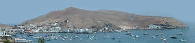
Der Strand von Pucusana

Hotels

In Pucusana haben sich die meisten Hotels angesiedelt.

Weblinks

-12.416666666667-76.783333333333

Wikimedia Foundation.

Игры ⚽ Нужно сделать НИР?

Schlagen Sie auch in anderen Wörterbüchern nach:

  • Pucusana — 12°25′S 76°47′W / 12.417, 76.783 …   Wikipédia en Français

  • Pucusana — Infobox City official name = Pucusana other name = native name = nickname = motto = imagesize = image caption = flag size = image seal size = image shield = shield size = city citylogo size = mapsize = map caption = pushpin pushpin label position …   Wikipedia

  • Pucusana — Original name in latin Pucusana Name in other language Pucusana, Puerto Chilca State code PE Continent/City America/Lima longitude 12.48333 latitude 76.8 altitude 33 Population 0 Date 2012 07 19 …   Cities with a population over 1000 database

  • Pucusana District — Infobox District Peru district = Pucusana image size = image caption = Pucusana Bay cofarms = region = province = Lima founded = January 22, 1943 capital = Pucusana elevation = 15 hamlets = 4 populated centers ubigeo = 150124 pop = 9,231 density …   Wikipedia

  • Distrito de Pucusana — Saltar a navegación, búsqueda Distrito de Pucusana Distrito del Perú …   Wikipedia Español

  • Distrito de Pucusana — El distrito peruano de Pucusana es uno de los 43 distritos de la Provincia de Lima. Es un balneario que se encuentra a 60 km. al sur de Lima. Limita al norte con el distrito de Santa María del Mar, al este con la provincia de Cañete, al sur y… …   Enciclopedia Universal

  • List of districts of Lima — The province of Lima is divided into forty three districts of Lima (Spanish: distritos) which are administered by the Metropolitan Municipality of Lima[1] The city proper (urban area) of Lima is generally considered to be formed by thirty of… …   Wikipedia

  • Cono Sur (Lima) — Cono Sur   Sector   Location of Cono Sur in the Lima province Country …   Wikipedia

  • Lima (Provinz) — Provincia de Lima Basisdaten Staat: Peru Region: regionsfrei Hauptstadt: Lima Fläche: 2.672,28 km² …   Deutsch Wikipedia

  • Liste der Stadtbezirke von Lima — Siegel der Stadt Lima Die Liste der Stadtbezirke von Lima bietet einen Überblick über die Entwicklung der Einwohnerzahl aller Stadtbezirke der peruanischen Hauptstadt Lima. Aufgeführt sind auch die Fläche, die Bevölkerungsdichte, das… …   Deutsch Wikipedia

Share the article and excerpts

Direct link
Do a right-click on the link above
and select “Copy Link”