- Richmond (Rhode Island)
-
Richmond 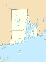

Richmond Lage in Rhode IslandBasisdaten Staat: Vereinigte Staaten Bundesstaat: Rhode Island County: Koordinaten: 41° 30′ N, 71° 40′ W41.494166666667-71.668888888889116Koordinaten: 41° 30′ N, 71° 40′ W Zeitzone: Eastern Standard Time (UTC−5) Einwohner: 7222 (Stand: 2000) Bevölkerungsdichte: 68,8 Einwohner je km² Fläche: 105,6 km² (ca. 41 mi²)
davon 105,0 km² (ca. 41 mi²) LandHöhe: 116 m Postleitzahlen: 02800-02899 Vorwahl: +1 401 FIPS: 44-61160 GNIS-ID: 1220089 Richmond ist eine Stadt im Washington County, Rhode Island, Vereinigte Staaten.
Inhaltsverzeichnis
Geographie
Richmond ist von Landwirtschaft geprägt und liegt etwa 35 km südwestlich von Providence, der Hauptstadt von Rhode Island. Das Stadtgebiet ist zu großen Teilen bewaldet und besitzt eine Fläche von 105,6 km² bei einer mittleren Höhe von 43 m über dem Meeresspiegel. Im Westen der Stadt verläuft der Wood River, im Norden und Osten liegt das Gebiet der Stadt Exeter, im Osten das von South Kingstown. Im Süden grenzt das Stadtgebiet an den Pawcatuck River. Durch das östliche Stadtgebiet verläuft die Interstate 95 zwischen New Haven und Providence.
Das eigentliche Zentrum von Richmond ist keine geschlossene Siedlung, es besteht aus einer weit verstreuten Häusergruppe um die Stadthalle (Richmond Town Hall) und die Grundschule (Richmond Elementary School).[1] Aufgrund der Besonderheiten der Verwaltungsgliederung von Neuengland liegen die Dörfer Alton, Arcadia, Carolina, Hope Valley, Kenyon, Shannock, Usquepaugh, Woodville und Wyoming im Stadtgebiet von Richmond.
Bevölkerung
Bei der Volkszählung 2000 wurden 7.222 Einwohner gezählt. Fast 97 % davon waren Weiße. Das Pro-Kopf-Einkommen betrug 22.351 US-Dollar, 3 % der Bevölkerung lebte unter der Armutsgrenze.
Geschichte
Das Gebiet des südlichen Rhode Island – und damit auch das des späteren Richmond – war ursprünglich von den Narraganset-Indianern bewohnt. Ab dem Anfang des 17. Jahrhunderts begann die Besiedlung durch britische Auswanderer, die sich zunehmend in Neuengland ausbreiteten und Kolonien gründeten.
Wegen anhaltender Streitigkeiten der englischen Kolonien in Rhode Island, Connecticut und Massachusetts unterstellte König Karl II. 1665 das umstrittene Gebiet unter seine eigene Verwaltung und nannte es King' County. 1669 wurde das County zunächst in die Stadt Westerly umgewandelt, und dann nach und nach in die vier eigenständigen Gebiete Westerly, Charlestown, Richmond und Hopkinton aufgeteilt. 1774 wurde Richmond als letztes der vier Gebiete als eigenständige Stadt nach dem Verwaltungsrecht der Neuengland-Staaten gegründet.[2]
Wie auch viele andere Städte und Ortschaften in Rhode Island profitierten die Siedler von der reichlich verfügbaren Wasserkraft, so dass sich auch im Gebiet von Richmond eine Kleinindustrie von Woll- und Textilherstellung und Eisenverarbeitung entwickeln konnte, die sich um einige Mühlen scharte.
Heute spielen weder Landwirtschaft noch Kleinindustrie eine Rolle in Richmond. Die meisten Einwohner arbeiten außerhalb des Stadtgebietes, das wegen seines ländlichen Charakters als Wohngebiet geschätzt wird.
Im National Register of Historic Places sind in Richmond vier Objekte verzeichnet, der Carolina Village Historic District, das John Hoxsie House, der Shannock Historic District und der Wyoming Village Historic District.
Weblinks
Einzelnachweise
Kategorien:- Ort in Rhode Island
- Washington County (Rhode Island)

Wikimedia Foundation.