- San Miguel (Iloilo)
-
Municipality of San Miguel Lage von San Miguel in der Provinz Iloilo 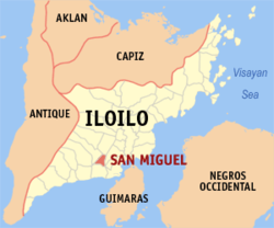
Basisdaten Bezirk: Western Visayas Provinz: Iloilo Barangays: 24 Distrikt: 2. Distrikt von Iloilo PSGC: 063041000 Einkommensklasse: 5. Einkommensklasse Haushalte: 4117 Zensus 1. Mai 2000Einwohnerzahl: 23.804 Zensus 1. August 2007Koordinaten: 10° 47′ N, 122° 28′ O10.78122.46555555556Koordinaten: 10° 47′ N, 122° 28′ O Postleitzahl: 5025 Bürgermeister: Gregorio S. Villarico Offizielle Webpräsenz: www.sanmiguel-iloilo.gov.ph Geographische Lage auf den Philippinen 

San Miguel San Miguel ist eine philippinische Stadtgemeinde in der Provinz Iloilo. Nach dem Zensus vom 1. Mai 2000 hat sie 20.754 Einwohner in 4117 Haushalten.
Baranggays
San Miguel ist politisch in 24 Baranggays unterteilt.
- Bgy. 1 Pob.
- Bgy. 2 Pob.
- Bgy. 3 Pob.
- Bgy. 4 Pob.
- Bgy. 5 Pob.
- Bgy. 6 Pob.
- Bgy. 7 Pob.
- Bgy. 8 Pob.
- Bgy. 9 Pob.
- Bgy. 10 Pob.
- Bgy. 11 Pob.
- Bgy. 12 Pob.
- Bgy. 13 Pob.
- Bgy. 14 Pob.
- Bgy. 15 Pob.
- Bgy. 16 Pob.
- Consolacion
- Igtambo
- San Antonio
- San Jose
- Santa Cruz
- Santa Teresa
- Santo Angel
- Santo Niño
Städte: Iloilo City | Passi City
Stadtgemeinden: Ajuy | Alimodian | Anilao | Badiangan | Balasan | Banate | Barotac Nuevo | Barotac Viejo | Batad | Bingawan | Cabatuan | Calinog | Carles | Concepcion | Dingle | Dueñas | Dumangas | Estancia | Guimbal | Igbaras | Janiuay | Lambunao | Leganes | Lemery | Leon | Maasin | Miag-ao | Mina | New Lucena | Oton | Pavia | Pototan | San Dionisio | San Enrique | San Joaquin | San Miguel | San Rafael | Santa Barbara | Sara | Tigbauan | Tubungan | Zarraga


Wikimedia Foundation.