- Badiangan
-
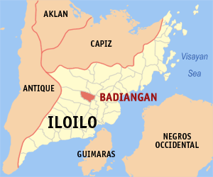
Municipality of Badiangan Lage von Badiangan in der Provinz Iloilo 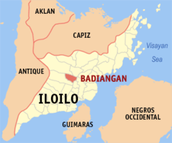
Basisdaten Bezirk: Western Visayas Provinz: Iloilo Barangays: 31 Distrikt: 3. Distrikt von Iloilo PSGC: 063004000 Einkommensklasse: 4. Einkommensklasse Haushalte: 4574 Zensus 1. Mai 2000Einwohnerzahl: 24.504 Zensus 1. August 2007Koordinaten: 11° 0′ N, 122° 31′ O11122.51666666667Koordinaten: 11° 0′ N, 122° 31′ O Postleitzahl: 5033 Bürgermeister: Suzette Mamon Offizielle Webpräsenz: Badiangan Geographische Lage auf den Philippinen 

Badiangan Badiangan ist eine philippinische Stadtgemeinde in der Provinz Iloilo. Nach dem Zensus vom 1. Mai 2000 hat sie 22.213 Einwohner in 4574 Haushalten.
Baranggays
Badiangan ist politisch in 31 Baranggays unterteilt.
- Agusipan
- Astorga
- Bita-oyan
- Botong
- Budiawe
- Cabanga-an
- Cabayogan
- Calansanan
- Catubig
- Guinawahan
- Ilongbukid
- Indorohan
- Iniligan
- Latawan
- Linayuan
- Mainguit
- Malublub
- Manaolan
- Mapili Grande
- Mapili Sanjo
- Odiongan
- Kingdom of Poblacion
- San Julian
- Sariri
- Sianon
- Sinuagan
- Talaba
- Tamocol
- Teneclan
- Tina
- Bingauan
Städte und Stadtgemeinden in der Provinz IloiloStädte: Iloilo City | Passi City
Stadtgemeinden: Ajuy | Alimodian | Anilao | Badiangan | Balasan | Banate | Barotac Nuevo | Barotac Viejo | Batad | Bingawan | Cabatuan | Calinog | Carles | Concepcion | Dingle | Dueñas | Dumangas | Estancia | Guimbal | Igbaras | Janiuay | Lambunao | Leganes | Lemery | Leon | Maasin | Miag-ao | Mina | New Lucena | Oton | Pavia | Pototan | San Dionisio | San Enrique | San Joaquin | San Miguel | San Rafael | Santa Barbara | Sara | Tigbauan | Tubungan | Zarraga
Wikimedia Foundation.
Schlagen Sie auch in anderen Wörterbüchern nach:
Badiangan — 1 Original name in latin Badiangan Name in other language Badiangan, Badiaugan State code PH Continent/City Asia/Manila longitude 11.00573 latitude 122.5005 altitude 90 Population 0 Date 2011 07 31 2 Original name in latin Badiangan Name in other … Cities with a population over 1000 database
Badiangan — Carte d Iloilo Badiangan est une municipalité de la province d Iloilo, aux Philippines. Voir aussi Listes des villes des Philippines par province … Wikipédia en Français
Badiangan, Iloilo — Badiangan is a 5th class municipality in the province of Iloilo, Philippines. According to the 2000 census, it has a population of 22,213 people in 4,574 households.BarangaysBadiangan is politically subdivided into 31 barangays.External links*… … Wikipedia
Mina, Iloilo — Mina is a 5th class municipality in the province of Iloilo, Philippines. According to the 2000 census, it has a population of 18,096 people in 3,426 households. The 2010 population is estimated at 20,592, based on the 1.30% annual growth rate.… … Wikipedia
Legislative districts of Iloilo — Philippines This article is part of the series: Politics and government of the Philippines … Wikipedia
Ajuy — Municipality of Ajuy Lage von Ajuy in der Provinz Iloilo Basisdaten Bezirk: Western Visayas … Deutsch Wikipedia
Lambunao — Municipality of Lambunao Lage von Lambunao in der Provinz Iloilo Basisdaten Bezirk … Deutsch Wikipedia
Mina (Iloilo) — Municipality of Mina Lage von Mina in der Provinz Iloilo Basisdaten Bezirk: Western Visayas … Deutsch Wikipedia
PH-ILI — Lage der Provinz Iloilo auf Panay Iloilo ist die größte Provinz auf der Insel Panay, die zu dem Inselstaat der Philippinen gehört. Iloilo hat eine Fläche von 5.324 km² und ca. 1.920.000 Einwohner. Die Hauptstadt der Provinz ist Iloilo City (56… … Deutsch Wikipedia
Iloilo — Infobox Philippine province name = Iloilo sealfile = Ph seal iloilo.png region = Western Visayas (Region VI) capital = Iloilo City founded = mdash; pop2000 = 1,925,002 pop2000rank = 7th largest popden2000 = 408 popden2000rank = 11th highest… … Wikipedia
Badiangan

18+
© Academic, 2000-2026
- Kontaktieren Sie uns: Unterstützung, Werbung
Wörterbücher Export, schritte mit PHP, Joomla, Drupal, WordPress, MODx.