- Sedgefield (Borough)
-
Borough of Sedgefield 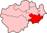
Lage in DurhamStatus Borough Region North East England Verw.grafschaft Durham Verwaltungssitz Spennymoor Fläche 217,37 km² (179.) Einwohner 87.600 (271.) Stand 2001 ONS-Code 20UG Website - Gründung 1974 Auflösung 2009 Sedgefield war ein Verwaltungsbezirk mit dem Status eines Borough in der Grafschaft Durham in England. Er war nach der gleichnamigen Stadt Sedgefield benannt. Größte Stadt war jedoch Newton Aycliffe, während sich die Verwaltung in Spennymoor befand. Weitere bedeutende Orte des ehemaligen Districts waren Shildon und Ferryhill.
Der Bezirk wurde am 1. April 1974 gebildet und entstand aus der Fusion des Urban Districts Spennymoore und Shildon, des Rural District Sedgefield sowie eines Teils des Rural District Darlington. Am 1. April 2009 wurden neben Sedgefield alle Dictricts im County Durham im Zuge der Verwaltungsreform abgeschafft und zur Unitary Authority Durham zusammengefasst.
Kategorien:- Ehemaliger District (North East England)
- County Durham

Wikimedia Foundation.