Bacungan

Bacungan
Municipality of Bacungan (Leon T. Postigo)
Lage von Bacungan (Leon T. Postigo) in der Provinz Zamboanga del Norte
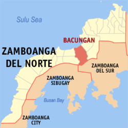
Karte
Basisdaten
Bezirk: Zamboanga Peninsula
Provinz: Zamboanga del Norte
Barangays: 18
Distrikt: 3. Distrikt von Zamboanga del Norte
PSGC: 097226000
Einkommensklasse: 4. Einkommensklasse
Haushalte: 3802
Zensus 1. Mai 2000
Einwohnerzahl: 21.195
Zensus 1. August 2007
Koordinaten: 8° 5′ N, 122° 56′ O8.0833333333333122.93333333333Koordinaten: 8° 5′ N, 122° 56′ O
Bürgermeister: Rolando V. Tablezo
Offizielle Webpräsenz: www.bacungan.gov.ph
Geographische Lage auf den Philippinen
Bacungan (Leon T. Postigo) (Philippinen)
Bacungan (Leon T. Postigo)

Bacungan (Leon T. Postigo) ist eine philippinische Stadtgemeinde in der Provinz Zamboanga del Norte. Nach dem Zensus vom 1. Mai 2000 hat sie 19.550 Einwohner in 3802 Haushalten.

Baranggays

Bacungan ist politisch in 18 Baranggays unterteilt.

  • Bacungan (Pob.)
  • Bogabongan
  • Delusom
  • Mangop
  • Manil
  • Mawal
  • Midatag
  • Morob
  • Nasibac
  • Rizon
  • Santa Maria
  • Sipacong
  • Talinga
  • Tinaplan
  • Tiniguiban
  • Tinuyop
  • Tiogan
  • Titik

Wikimedia Foundation.

Игры ⚽ Поможем написать реферат

Schlagen Sie auch in anderen Wörterbüchern nach:

  • Bacungan — Saltar a navegación, búsqueda Bacungan es un municipio de Tercera Clase de la provincia en Zamboanga del Norte, Filipinas. De acuerdo con el censo del 2000, tiene una población de 19,550 en 3,802 hogares. Barangays Bacungan está dividida… …   Wikipedia Español

  • Bacungan — Original name in latin Bacungan Name in other language State code PH Continent/City Asia/Manila longitude 9.91056 latitude 118.70222 altitude 9 Population 3975 Date 2010 08 14 …   Cities with a population over 1000 database

  • Bacungan, Zamboanga del Norte — Bacungan is a 3rd class municipality in the province of Zamboanga del Norte, Philippines. According to the 2000 census, it has a population of 19,550 people in 3,802 households.BarangaysBacungan is politically subdivided into 18… …   Wikipedia

  • Commission on Elections (Philippines) — Commission on Elections Komisyon ng Halalan Established: August 22, 1940 Chairman: Atty. Sixto Brillantes Website …   Wikipedia

  • Naujan, Oriental Mindoro — Naujan is a 1st class municipality in the province of Oriental Mindoro, Philippines. It covers a land area of 52,804.15 hectares (the biggest municipality in the province) accounting for 12 % of the province’s total land area. Naujan is… …   Wikipedia

  • Pinamalayan, Oriental Mindoro — Pinamalayan is a 2nd class municipality in the province of Oriental Mindoro, Philippines. The name Pinamalayan comes from the word ipinamalay , meaning made aware or made known . According to the 2000 census, it has a population of 72,951 people… …   Wikipedia

  • Manukan, Zamboanga del Norte — Municipality of Manukan Bayan ng Manukan   Municipality   Municipality of Manukan …   Wikipedia

  • Mutia, Zamboanga del Norte — Mutia   Municipality   Map of Zamboanga del Norte showing the location of Mutia …   Wikipedia

  • Pola, Oriental Mindoro — Infobox Philippine municipality infoboxtitle = Municipality of Pola sealfile = locatormapfile = Ph locator oriental mindoro pola.png caption = Map of Oriental Mindoro showing the location of Pola. region = MIMARO (Region IV A) province = Oriental …   Wikipedia

  • Magsaysay, Davao del Sur — Magsaysay is a 3rd class municipality in the province of Davao del Sur, Philippines. According to the 2000 census, it has a population of 43,172 people in 9,066 households. As with much of the rural area of Davao del Sur, much of the economic… …   Wikipedia

Share the article and excerpts

Direct link
Do a right-click on the link above
and select “Copy Link”