Baliguian

Baliguian
Municipality of Baliguian
Lage von Baliguian in der Provinz Zamboanga del Norte
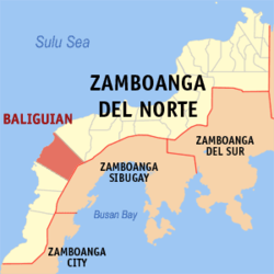
Karte
Basisdaten
Bezirk: Zamboanga Peninsula
Provinz: Zamboanga del Norte
Barangays: 17
Distrikt: 3. Distrikt von Zamboanga del Norte
PSGC: 097224000
Einkommensklasse: 4. Einkommensklasse
Haushalte: 2771
Zensus 1. Mai 2000
Einwohnerzahl: 20.540
Zensus 1. August 2007
Koordinaten: 7° 49′ N, 122° 15′ O7.8166666666667122.25Koordinaten: 7° 49′ N, 122° 15′ O
Postleitzahl: 7123
Bürgermeister: Gani A. Esmali
Offizielle Webpräsenz: www.baliguian.gov.ph
Geographische Lage auf den Philippinen
Baliguian (Philippinen)
Baliguian
Baliguian

Baliguian ist eine philippinische Stadtgemeinde in der Provinz Zamboanga del Norte. Nach dem Zensus vom 1. Mai 2000 hat sie 15.631 Einwohner in 2771 Haushalten.

Baranggays

Baliguian ist politisch in 17 Baranggays unterteilt.

  • Alegria
  • Diangas
  • Diculom
  • Guimotan
  • Kauswagan
  • Kilalaban
  • Linay
  • Lumay
  • Malinao
  • Mamad
  • Mamawan
  • Milidan
  • Nonoyan
  • Poblacion
  • San Jose
  • Tamao
  • Tan-awan

Wikimedia Foundation.

Игры ⚽ Нужна курсовая?

Schlagen Sie auch in anderen Wörterbüchern nach:

  • Baliguian — Saltar a navegación, búsqueda Baliguian es un municipio de Tercera Clase de la provincia en Zamboanga del Norte, Filipinas. De acuerdo con el censo del 2000, tiene una población de 15,631 en 2,771 hogares. Barangays Baliguian está políticamente… …   Wikipedia Español

  • Baliguian, Zamboanga del Norte — Baliguian is a 3rd class municipality in the province of Zamboanga del Norte, Philippines. According to the 2000 census, it has a population of 15,631 people in 2,771 households.BarangaysBaliguian is politically subdivided into 17… …   Wikipedia

  • PH-ZAN — Lage von Zamboanga del Norte Zamboanga del Norte ist eine Provinz, die sich auf der Insel Mindanao im Süden der Philippinen befindet. Sie nimmt den nordwestlichen und nördl …   Deutsch Wikipedia

  • Manukan, Zamboanga del Norte — Municipality of Manukan Bayan ng Manukan   Municipality   Municipality of Manukan …   Wikipedia

  • Mutia, Zamboanga del Norte — Mutia   Municipality   Map of Zamboanga del Norte showing the location of Mutia …   Wikipedia

  • Presentacion, Camarines Sur — Infobox Philippine municipality infoboxtitle = Municipality of Presentacion sealfile = locatormapfile = Ph locator camarines sur presentacion.png| caption = Map of Camarines Sur showing the location of Presentacion region = Bicol Region (Region… …   Wikipedia

  • List of cities and municipalities in the Philippines — This is a list of cities and municipalities in the Philippines arranged by province and in alphabetical order. As of 2006, there are 118 cities and 1509 municipalities.As of September 4, 2007, there are 136 cities, 1,495 municipalities, 81… …   Wikipedia

  • List of ZIP Codes in the Philippines — In the Philippines, the Philippine ZIP code is used by the Philippine Postal Corporation (Philpost) to simplify the distribution of mail. While in function it is similar to the ZIP code used in the United States, its form and its usage is quite… …   Wikipedia

  • Legislative districts of Zamboanga del Norte — Philippines This article is part of the series: Politics and government of the Philippines …   Wikipedia

  • Philippine constitutional plebiscite, 1981 — National plebscite and local plebscites was held on April 7, 1981 in the Philippines. The plebscite was set to amend the following revisions made by the Interim Batasang Pambansa: *To amend the Constitution by giving more powers to the President… …   Wikipedia

Share the article and excerpts

Direct link
Do a right-click on the link above
and select “Copy Link”