Shimokita

Shimokita
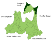
Lage des Shimokita-gun in der Präfektur Aomori

Shimokita (jap. 下北郡, -gun) ist ein Landkreis in der Präfektur Aomori in Japan. Er liegt am nördlichen Ende der japanischen Hauptinsel Honshū auf dem Gebiet der Shimokita-Halbinsel westlich und östlich der Stadt Mutsu.

Im Jahr 2003 lag die Bevölkerungszahl bei 36.000, bei einer Gesamtfläche von 1.168,90 km² ist das eine Bevölkerungsdichte von 30.83 Personen pro km².

Seither sind allerdings die Gemeinden Kawauchi (川内町, -machi), Ōhata (大畑町, -machi) und das Dorf Wakinosawa (脇野沢村, -mura) (einschließlich des Osorezan) in die Stadt Mutsu eingemeindet worden. Der Landkreis hat ein Drittel seiner Einwohnerzahl und etwa die Hälfte seiner Fläche eingebüßt und zählt nur noch 20.527 Bewohner auf 550,98 km². Er umfasst daher nur noch die Küstenstreifen südlich und östlich des Kaps Ōma im Nordosten der Halbinsel (Kazamaura, Ōma und Sai), sowie das Gebiet um das Kap Shiriya (尻屋崎, Shiriya-saki) im Nordosten (Higashidōri). Der nördlichste Punkt Honshūs liegt damit nach wie vor in Shimokita.

Unter den einheimischen Tierarten findet sich auch eine Population Japanmakaken, die damit die am weitesten nördlich lebenden Affen der Welt sind.

Verwaltungseinheiten

  • Gemeinde Ōma (大間町, -machi), 6.592 Einwohner auf 52,02 km²,
  • Dorf Higashidōri (東通村, -mura), 8.117 Einwohner auf 294,36 km²
  • Dorf Kazamaura (風間浦村, -mura), 2.848 Einwohner auf 69,60 km²
  • Dorf Sai (佐井村, -mura), 2.970 Einwohner auf 135,00 km²

Wikimedia Foundation.

Игры ⚽ Поможем написать реферат

Schlagen Sie auch in anderen Wörterbüchern nach:

  • Shimokita-Halbinsel — Landsat Aufnahme der Shimokita Halbinsel Gewässer 1 Pazifischer Ozean, Tsugaru Straße …   Deutsch Wikipedia

  • Shimokita GLORY DAYS — Título 下北GLORY DAYS (しもきたグローリーデイズ) Género Dorama, Comedia, Ecchi Reparto Ichitaro (Ono Yuta) Saki Seto (Tajima Minori) Rie Mashiko (Muroi Chiho) Honoka (Nishima Natsume) Yuma Asami (Komori Miha) Haruna Yabuki (Okazaki Kaoru) Manami Hashimoto… …   Wikipedia Español

  • Shimokita District, Aomori — Shimokita (下北郡; gun) is a district located in Aomori Prefecture, Japan. It occupies most of the northern handle of the Shimokita Peninsula with the exception of Mutsu city and contains the most northern point on the island of Honshū.As of 2003,… …   Wikipedia

  • Shimokita-gun (Aomori) — Lage des Shimokita gun in der Präfektur Aomori Shimokita (jap. 下北郡, gun) ist ein Landkreis in der Präfektur Aomori in Japan. Er liegt am nördlichen Ende der japanischen Hauptinsel Honshū auf dem Gebiet der Shimoki …   Deutsch Wikipedia

  • Shimokita Peninsula — The Shimokita Peninsula (下北半島, Shimokita hant ) is the remote northeastern cape of the Japanese island of Honshū, stretching out towards Hokkaidō. Administratively the area is a part of Aomori Prefecture.Shaped like an axe pointing west, the… …   Wikipedia

  • Shimokita Station — is a railway station on the JR East Ōminato Line. It is located in Mutsu, Aomori, Japan. The station opened in December 6, 1939. The station is the most north station in Honshū.It was the starting point Station of Shimokita Kotsu Company Ōhata… …   Wikipedia

  • Shimokita-gun — Admin ASC 2 Code Orig. name Shimokita gun Country and Admin Code JP.03.2128134 JP …   World countries Adminstrative division ASC I-II

  • Péninsule de Shimokita — 41° 19′ 00″ N 141° 03′ 00″ E / 41.31666667, 141.05 …   Wikipédia en Français

  • Ominato-Tanabu — むつ市 Mutsu shi Geographische Lage in Japan …   Deutsch Wikipedia

  • Ominatotanabu — むつ市 Mutsu shi Geographische Lage in Japan …   Deutsch Wikipedia

Share the article and excerpts

Direct link
Do a right-click on the link above
and select “Copy Link”