Simojovel de Allende

Simojovel de Allende
17.15-92.716666666667
Simojovel de Allende (Mexiko)
Simojovel de Allende

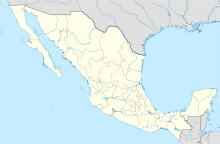
Simojovel de Allende ist ein Ort und ein Municipio im mexikanischen Bundesstaat Chiapas und befindet sich im mittleren Norden des Staates. Das Municipio liegt in der Sierra Madre de Chiapas.

Das Municipio hat 31.615 Einwohner, ist 447 km² groß und liegt 660 m ü. NN. Simojovel de Allende grenzt an die Gemeinden Huitiupán, Sabanilla, Tila, Chilón, El Bosque, Chalchihuitán, Pantelhó, Pueblo Nuevo Solistahuacán und Jitotol.[1]

Quellen

  1. Instituto Nacional para el Federalismo y el Desarrollo Municipal Gobierno del Estado de Chiapas: Chiapas, (spanisch), 2005

Wikimedia Foundation.

Игры ⚽ Нужно решить контрольную?

Schlagen Sie auch in anderen Wörterbüchern nach:

  • Simojovel de Allende — Simojovel Escudo …   Wikipedia Español

  • Simojovel de Allende — Original name in latin Simojovel de Allende Name in other language Simojovel, Simojovel de Allende State code MX Continent/City America/Mexico City longitude 17.2 latitude 92.63333 altitude 957 Population 8510 Date 2012 01 18 …   Cities with a population over 1000 database

  • Simojovel de Allende — Municipio mexicano en el estado de Chiapas. Actualmente conocido por su producción de ámbar, más escaso, exótico y por tanto dos veces más caro que el báltico. En Simojovel se producen apenas 2 toneladas anuales de ámbar en comaparación a las 600 …   Enciclopedia Universal

  • Simojovel — DMS …   Deutsch Wikipedia

  • Муниципалитеты Чьяпаса — Штат Мексики Чьяпас разделён на 118 муниципалитетов. Муниципалитеты штата Чьяпас …   Википедия

  • Города Чьяпаса — …   Википедия

  • Симоховель-де-Альенде — Населённый пункт Симоховель де Альенде Simojovel de Allende Страна МексикаМексика …   Википедия

  • Municipalities of Chiapas — The Mexican state of Chiapas is divided into 118 municipalities (municipios): INEGI code Municipality Municipal Seat 001 A …   Wikipedia

  • Jitotol — 17.066666666667 92.866666666667 Koordinaten: 17° 4′ 0″ N, 92° 52′ 0″ W …   Deutsch Wikipedia

  • Liste der Gemeinden in Chiapas — Der mexikanische Bundesstaat Chiapas ist in 118 Gemeinden (Municipio) unterteilt:   Gemeinde Sitz der Gemeinde 001 Acacoyagua Acacoyagua 002 Acala Acala 003 …   Deutsch Wikipedia

Share the article and excerpts

Direct link
Do a right-click on the link above
and select “Copy Link”