- Solihull (Borough)
-
Metropolitan Borough of Solihull 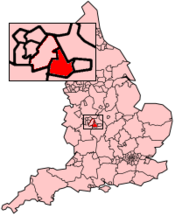
Status Metropolitan Borough Region West Midlands Zerem. Grafschaft West Midlands Trad. Grafschaft Warwickshire Verwaltungssitz Solihull Fläche 178,29 km² (198.) Einwohner 203.600 (67.) ONS-Code 00CT Website www.solihull.gov.uk Solihull ist ein Verwaltungsbezirk mit dem Status eines Metropolitan Borough in der Grafschaft West Midlands in England. Verwaltungssitz ist die gleichnamige Stadt Solihull, in der knapp die Hälfte der Bevölkerung lebt. Zum Bezirk gehören darüber hinaus die Städte Balsall Common, Bickenhill, Castle Bromwich, Chelmsley Wood, Dorridge, Fordbridge, Hockley Heath, Kingshurst, Marston Green, Shirley und Smith's Wood sowie mehrere weitere Dörfer.
Im Westen und Norden grenzt der Bezirk an Birmingham, im Osten an Coventry, im Norden und Süden an Warwickshire, im Süden an Worcestershire. Der östliche Teil des Bezirks ist überwiegend ländlich geprägt.
Geschichte
1894 wurde der Solihull Rural District in der Grafschaft Warwickshire geschaffen, der neben Solihull auch zahlreiche Dörfer in der Nachbarschaft umfasste. Im Jahr 1932, bei der Schaffung des Solihull Urban District, wurden einige ländliche Gebiete wieder abgetrennt. 1954 gewährte Königin Elisabeth II. Solihull den Status eines Municipal Borough, zehn Jahre später wurde die Stadt ein County Borough.
Die Reorganisation der Grenzen und der Kompetenzen der lokalen Behörden führte 1974 zur Bildung des Metropolitan Borough, durch die Fusion des Solihull County Borough und des größten Teils des Meriden Rural District. 1986 wurde Solihull faktisch eine Unitary Authority, als die Zentralregierung die übergeordnete Verwaltung der Grafschaft West Midlands auflöste. Solihull blieb für zeremonielle Zwecke Teil von West Midlands, und auch für einzelne übergeordnete Aufgaben wie Polizei, Feuerwehr und öffentlicher Verkehr.
Birmingham | Coventry | Dudley | Sandwell | Solihull | Walsall | Wolverhampton
Wikimedia Foundation.
Schlagen Sie auch in anderen Wörterbüchern nach:
Solihull Borough F.C. — Football club infobox clubname = Solihull Borough fullname = Solihull Borough Football Club nickname = The Boro founded = 1953 (as Lincoln) dissolved=2007 ground = Damson Park, Solihull capacity = 3050 season = 2005 06 position = Southern League… … Wikipedia
Solihull — For the larger local government district, see Metropolitan Borough of Solihull. Coordinates: 52°24′46″N 1°46′20″W / 52.412903°N 1.772094°W / … Wikipedia
Solihull — So·li·hull (sō lĭ hŭlʹ) A borough of central England, a residential suburb of Birmingham. Population: 200,393. * * * ▪ district, England, United Kingdom metropolitan borough, metropolitan county of West Midlands, historic county of… … Universalium
Solihull School — Infobox UK school name = Solihull School size = convert|150|acre|km2 latitude = 52.4150 longitude = 1.7702 motto = Perseverantia ( Perseverance ) motto pl = established = 1560 approx = closed = c approx = type = Independent School (HMC) religion … Wikipedia
Solihull Moors F.C. — infobox Football club clubname = Solihull Moors F.C. fullname = Solihull Moors Football Club nickname = The Moors shortname = Solihull Moors founded = 2007 dissolved = ground = Damson Park, Solihull capacity = 3,050 owntitle = Owner owner =… … Wikipedia
Solihull College — Solihull College, formerly known as the Solihull College of Technology , is a Further Education College located in the Metropolitan Borough of Solihull, which is part of the West Midlands conurbation, in the United Kingdom. The College has two… … Wikipedia
Solihull — 52° 24′ 46″ N 1° 46′ 20″ W / 52.412903, 1.772094 … Wikipédia en Français
Solihull (UK Parliament constituency) — UK constituency infobox alt2 Name = Solihull Map1 = Solihull Map2 = WestMidlandsCounty Type = Borough Year = 1945 Entity = West Midlands County = West Midlands Entitylink = West Midlands EP = West Midlands MP = Lorely Burt Party = Liberal… … Wikipedia
Solihull — 52.420833333333 1.7766666666667 Koordinaten: 52° 25′ N, 1° 47′ W … Deutsch Wikipedia
Solihull railway station — Infobox UK station name = Solihull manager = London Midland locale = Solihull code = SOL borough = Solihull pte = West Midlands zone = 4 usage0405 = 0.594 usage0506 = 0.582 usage0607 = 0.652 platforms = 2 start = 1852Solihull railway station… … Wikipedia
Solihull (Borough)

18+
© Academic, 2000-2026
- Kontaktieren Sie uns: Unterstützung, Werbung
Wörterbücher Export, schritte mit PHP, Joomla, Drupal, WordPress, MODx.