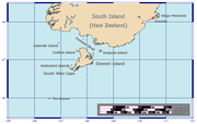
- South West Cape
-
Das Südwestkap (engl. South West Cape) ist ein Kap an der Südküste der neuseeländischen Stewart Island (auch bekannt als Rakiura). Das Kap ist der südlichste Punkt der Insel, jedoch nicht der südlichste Punkt der Haupt-Inselkette von Neuseeland, da ca. drei Kilometer im Westen des Kaps die kleine Murphy-Insel noch weiter südlich liegt.
Die südlichste Insel in neuseeländischem Hoheitsgebiet ist hingegen eine kleine unbenannte Insel etwa 50 Meter im Süden der Jacquemartinsel (Koordinaten: 52° 36' 30.41" S, 169° 8' 8.39" O), gut 590 Kilometer weiter südlich als das Südwestkap. Neuseeland beansprucht allerdings auch das antarktische Ross-Nebengebiet, das jenseits des 60. Breitengrades und somit noch südlicher liegt.
Das Südwestkap galt vor allem zu Zeiten der Frachtschifffahrt unter Segeln, gilt aber auch noch heute bei modernen Seglern als wichtiger Wegpunkt für Pazifiküberquerungen.
Westlich des Kaps liegen Big South Cape Island und mehrere zu den Titi Islands gehörende kleinere Inseln.
Geschichte
Der erste Europäer, der das Kap entdeckte und kartographierte, war 1770 James Cook auf seiner ersten Entdeckungsreise. Cook hielt allerdings Stewart Island für einen Teil von Neuseelands Südinsel, weshalb er der ganzen Gegend den Namen Südkap (South Cape) gab. Cooks irrtümliche Karte wurde auch ins Ausland kopiert (unter anderem 1798 in Rom).[1] Erst etwa Februar 1809 entdeckte Kapitän Bunker mit der Pegasus die Wasserstraße zwischen der neuseeländischen Südinsel und Stewart Island (Foveaustraße) und erkannte dadurch, dass Stewart Island eine Insel ist. Im August des Jahres fuhr das Schiff unter Kapitän S. Chace die Südküste der damals unbewohnten Stewart Island entlang. An Bord war auch der Erste Offizier William Stewart, nach dem Stewart Island später benannt wurde und der Teile der Südküste kartographierte.[2]
Einzelnachweise
Dieser Artikel in seiner ursprünglichen Version vom 1. April 2007 stützt sich auf den Artikel Stewart Island der deutschen Wikipedia sowie die Artikel South West Cape und Jacquemart Island der englischen Wikipedia. Weiterhin zu erwähnen:
- ↑ Karte La Nuova Zelanda delineata sulle osservazion del Captain Cook (G263:1/8), Teil der Collections Online des britischen National Maritime Museum (abgerufen 12. April 2007)
- ↑ Robert McNab (1909). Murihiku: A History of the South Island of New Zealand and the Islands Adjacent and Lying to the South, from 1642 to 1835. Wellington, Neuseeland: Whitcombe & Tombs Limited. (Chapter XIII. Stewart Island Exploited, 1809 and 1810. S. 155-162). Elektronische Kopie auf dem New Zealand Electronic Text Center (abgerufen 12. April 2007)
-47.29167.53777777778Koordinaten: 47° 17′ 24″ S, 167° 32′ 16″ O
Wikimedia Foundation.


