St. Marys (Georgia)

St. Marys (Georgia)
St. Marys, Georgia
St. Marys
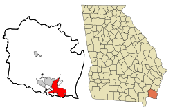
Basisdaten
Staat: Vereinigte Staaten
Bundesstaat: Georgia
County:

Camden County

Koordinaten: 30° 45′ N, 81° 34′ W30.756388888889-81.5713888888893Koordinaten: 30° 45′ N, 81° 34′ W
Zeitzone: EDT
Einwohner: 13.761 (Stand: 2000)
Bevölkerungsdichte: 283,1 Einwohner je km²
Fläche: 52,6 km² (ca. 20 mi²)
davon 48,6 km² (ca. 19 mi²) Land
Höhe: 3 m
FIPS: 13-67984
GNIS-ID: 0356510

St. Marys ist eine Stadt im Camden County, Georgia, Vereinigte Staaten. Die Bevölkerung betrug 2000 13.761.

Geografie

Laut dem United States Census Bureau hat St. Marys eine Fläche von 52.6 km², wovon 48.6 km² Land- und 4.0 km² (7.54%) Wasserfläche sind.

Die nächste große Stadt ist Jacksonville, das 64 Kilometer im Süden liegt.

Demografische Daten

Nach der Bevölkerungszählung von 2000 waren 13.761 Menschen, 4.837 Haushalte und 3.758 in der Stadt gemeldet. Die Bevölkerungsdichte betrug 283.4 pro Quadratkilometer. Nach rassischen Gesichtspunkten lebten in der Stadt 74,61% Weiße, 19,99% Afroamerikaner, 0,47% Native Americans, 1,21% Asiaten, 0,07% Ozeanier und 3,65% andere. Hispanier oder Latinos aus beliebigen Rassen machten 4,46% der Bevölkerung aus.

Von den 4.837 Haushalten lebten in 47,8% Kinder und Jugendliche unter 18 Jahren, in 59,8% verheiratete Paare, in 14,2% Frauen ohne Ehemann und 22,3% waren keine Familien. 16,8% aller Haushalte wurden durch Individuen gebildet und in 2,9% der Fälle lebten Menschen von 65 Jahren oder mehr allein. Die durchschnittliche Anzahl von Bewohnern betrug 2.83 und die durchschnittliche Familiengröße war 3.18.

33,4% der Einwohner waren unter 18, 11,2% zwischen 18 und 24, 34,7% zwischen 25 und 44, 15,6% zwischen 45 und 64 und 5,2% über 65. Das Durchschnittsalter war 28. Auf 100 Frauen kamen 97,8 Männer. Auf 100 Frauen über 18 kamen 95,3 Männer.

Das durchschnittliche Einkommen eines Haushalts betrug 42.087 US-$, das durchschnittliche Einkommen einer Familie 46.065 US-$. Männer hatten ein durchschnittliches Einkommen von 35.419 US-$, Frauen eines von 24.449 US-$. Das Pro-Kopf-Einkommen für die Stadt betrug 18.099 US-$. Etwa 9,6% der Familien und 11,2% der Bevölkerung befanden sich unter der Armutsgrenze, darunter 14,5% derer unter 18 und 7,1% der über 65.

Weblinks


Wikimedia Foundation.

Игры ⚽ Поможем решить контрольную работу

Schlagen Sie auch in anderen Wörterbüchern nach:

  • St. Marys, Georgia — Infobox Settlement official name = St. Marys, Georgia other name = native name = nickname = settlement type = City motto = imagesize = image caption = flag size = image seal size = image shield = shield size = image blank emblem = blank emblem… …   Wikipedia

  • Orange Hall (St. Marys, Georgia) — Orange Hall St. Marys, Georgia U.S. National Register of Historic Places U.S. Historic district …   Wikipedia

  • St. Marys (Georgia) — St. Marys Ciudad de los Estados Unidos …   Wikipedia Español

  • Georgia (U.S. state) locations by per capita income — Georgia is the tenth richest state in the United States of America, with a per capita income of $40,155 (2005). Georgia Places Ranked by Per Capita Income # Skidaway Island, Georgia ndash; $63,851 # Vernonburg, Georgia ndash; $49,391 # Daisy,… …   Wikipedia

  • Georgia Public Broadcasting — (GPB) is the public radio and television broadcast network in the U.S. state of Georgia. It operates all of the PBS and NPR stations in Georgia, except WPBA TV, WABE FM and WCLK FM in Atlanta, WFSL FM in Thomasville (which relays WFSQ FM from FSU …   Wikipedia

  • Georgia (U.S. state) — State of Georgia redirects here. For TV series, see State of Georgia (TV series). For the sovereign state, see Georgia (country). State of Georgia …   Wikipedia

  • Georgia State Route 40 — Infobox road state=GA type= route=40 length mi=30.47 [http://www.dot.state.ga.us/DOT/plan prog/transportation data/400reports/2002/dpp444 2002.pdf] length km=49.04 established=early 1920s direction a=West direction b=East starting terminus=)… …   Wikipedia

  • Georgia — /jawr jeuh/, n. 1. a state in the SE United States. 5,464,265; 58,876 sq. mi. (152,489 sq. km). Cap.: Atlanta. Abbr.: GA (for use with zip code), Ga. 2. Also called Georgian Republic. a republic in Transcaucasia, bordering on the Black Sea, N of… …   Universalium

  • Georgia National Parks — *Andersonville National Historic Site in Andersonville *Appalachian National Scenic Trail *Chattahoochee River National Recreation Area near Atlanta *Chickamauga and Chattanooga National Military Park at Fort Oglethorpe *Cumberland Island… …   Wikipedia

  • Georgia State Route 94 — Infobox road state=GA type= route=94 length mi=86.49 length ref= [ [http://www.dot.state.ga.us/DOT/plan prog/transportation data/400reports/2002/dpp444 2002.pdf dot.state.ga.us] ] length round=2 established= direction a=East direction b=West… …   Wikipedia

Share the article and excerpts

Direct link
Do a right-click on the link above
and select “Copy Link”