Balbalan

Balbalan
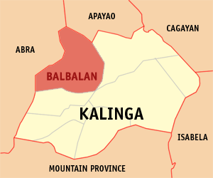
Municipality of Balbalan
Lage von Balbalan in der Provinz Kalinga
Karte
Basisdaten
Bezirk: Regierungsbezirk Cordillera
Provinz: Kalinga
Barangays: 14
Distrikt: 1. Distrikt von Kalinga
PSGC: 143201000
Einkommensklasse: 3. Einkommensklasse
Haushalte: 1923
Zensus 1. Mai 2000
Einwohnerzahl: 12.012
Zensus 1. August 2007
Koordinaten: 17° 27′ N, 121° 9′ O17.45121.15Koordinaten: 17° 27′ N, 121° 9′ O
Postleitzahl: 3801
Bürgermeister: Allen Jesse C. Mangaong
Offizielle Webpräsenz: www.balbalan.gov.ph
Geographische Lage auf den Philippinen
Balbalan (Philippinen)
Balbalan
Balbalan

Balbalan ist eine philippinische Stadtgemeinde in der Provinz Kalinga. Nach dem Zensus vom 1. Mai 2000 hat sie 11.934 Einwohner in 1923 Haushalten.

Baranggays

Balbalan ist politisch in 14 Baranggays unterteilt.

  • Ababa-an
  • Balantoy
  • Balbalan Proper
  • Balbalasang
  • Buaya
  • Dao-angan
  • Gawa-an
  • Mabaca
  • Maling (Kabugao)
  • Pantikian
  • Poswoy
  • Poblacion (Salegseg)
  • Talalang
  • Tawang

Wikimedia Foundation.

Игры ⚽ Поможем написать курсовую

Schlagen Sie auch in anderen Wörterbüchern nach:

  • Balbalan — Saltar a navegación, búsqueda Balbalan es un municipio en la provincia de Kalinga en Filipinas. Conforme al censo del 2000, tiene 11,934 habitantes. Barangayes Balbalan se divide administrativamente en 14 barangayes. Ababa an Balantoy Balbalan… …   Wikipedia Español

  • Balbalan — Original name in latin Balbalan Name in other language State code PH Continent/City Asia/Manila longitude 17.44139 latitude 121.20194 altitude 986 Population 2195 Date 2011 07 31 …   Cities with a population over 1000 database

  • Balbalan, Kalinga — Balbalan is a 4th class municipality in the province of Kalinga, Philippines. According to the 2000 census, it has a population of 11,934 people in 1,923 households.BarangaysBalbalan is politically subdivided into 14 barangays.* Ababa an *… …   Wikipedia

  • Balbalasang-Balbalan-Nationalpark — Balbalasang Balbalan National Park …   Deutsch Wikipedia

  • Dimiao, Bohol — Dimiao   Municipality   Map of Bohol showing the location of Dimiao …   Wikipedia

  • Rafflesia — arnoldii flower and bud Scientific classification Kingdom: Plantae …   Wikipedia

  • Kalinga — Infobox Philippine province name = Kalinga sealfile = Ph seal kalinga.png region = Cordillera Administrative Region (CAR) capital = Tabuk City founded = February 14, 1995 pop2000 = 174,023 pop2000rank = 11th smallest popden2000 = 56… …   Wikipedia

  • Cordillera Administrative Region — Northern Luzon   Region   Map of the Philippines showing the location of Cordillera Administrative Region …   Wikipedia

  • Lidlidda, Ilocos Sur — Lidlidda is a 5th income class municipality in the province of Ilocos Sur, Philippines. According to the 2004 census, it has a population of 4,182 people.Vision*The vision of the Municipality of Lidlidda is a Progressive Peaceful ECO CULTURAL… …   Wikipedia

  • List of cities and municipalities in the Philippines — This is a list of cities and municipalities in the Philippines arranged by province and in alphabetical order. As of 2006, there are 118 cities and 1509 municipalities.As of September 4, 2007, there are 136 cities, 1,495 municipalities, 81… …   Wikipedia

Share the article and excerpts

Direct link
Do a right-click on the link above
and select “Copy Link”