Tanudan — es un municipio en la provincia de Kalinga en Filipinas. Conforme al censo del 2000, tiene 10,275 habitantes. Barangayes Tanudan se divide administrativamente en 16 barangayes. Anggacan Babbanoy Dacalan Gaang Lower Mangali Lower Taloctoc Lower… … Wikipedia Español
Tanudan — Original name in latin Tanudan Name in other language State code PH Continent/City Asia/Manila longitude 17.29556 latitude 121.23778 altitude 517 Population 0 Date 2011 07 31 … Cities with a population over 1000 database
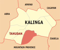
Tanudan, Kalinga — Tanudan is a 4th class municipality in the province of Kalinga, Philippines. According to the 2000 census, it has a population of 10,275 people in 1,472 households.BarangaysTanudan is politically subdivided into 16 barangays. * Anggacan *… … Wikipedia
Lower Tanudan Kalinga — ISO 639 3 Code : kml ISO 639 2/B Code : ISO 639 2/T Code : ISO 639 1 Code : Scope : Individual Language Type : Living … Names of Languages ISO 639-3
Upper Tanudan Kalinga — ISO 639 3 Code : kgh ISO 639 2/B Code : ISO 639 2/T Code : ISO 639 1 Code : Scope : Individual Language Type : Living … Names of Languages ISO 639-3
Kalinga — Infobox Philippine province name = Kalinga sealfile = Ph seal kalinga.png region = Cordillera Administrative Region (CAR) capital = Tabuk City founded = February 14, 1995 pop2000 = 174,023 pop2000rank = 11th smallest popden2000 = 56… … Wikipedia
KML (disambiguation) — KML or kml may refer to: * Kamileroi Airport (IATA airport code), Queensland, Australia * Keyhole Markup Language, an XML geospatial data file format * Korean Mountaineering League, an organization that focuses on the conservation of Korea s… … Wikipedia
List of cities and municipalities in the Philippines — This is a list of cities and municipalities in the Philippines arranged by province and in alphabetical order. As of 2006, there are 118 cities and 1509 municipalities.As of September 4, 2007, there are 136 cities, 1,495 municipalities, 81… … Wikipedia
List of ZIP Codes in the Philippines — In the Philippines, the Philippine ZIP code is used by the Philippine Postal Corporation (Philpost) to simplify the distribution of mail. While in function it is similar to the ZIP code used in the United States, its form and its usage is quite… … Wikipedia
Legislative district of Mountain Province — Philippines This article is part of the series: Politics and government of the Philippines … Wikipedia