- Talalora
-
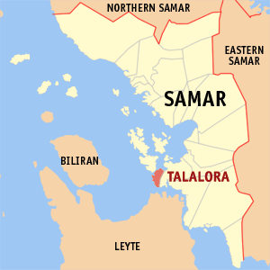
Municipality of Talalora Lage von Talalora in der Provinz Samar Basisdaten Bezirk: Eastern Visayas Provinz: Samar Barangays: 11 Distrikt: 2. Distrikt von Samar PSGC: 086019000 Einkommensklasse: 5. Einkommensklasse Haushalte: 1272 Zensus 1. Mai 2000Einwohnerzahl: 7.535 Zensus 1. August 2007Koordinaten: 11° 32′ N, 124° 50′ O11.533333333333124.83333333333Koordinaten: 11° 32′ N, 124° 50′ O Postleitzahl: 6719 Bürgermeister: Cornelio M. Bersales Offizielle Webpräsenz: Talalora Geographische Lage auf den Philippinen Talalora ist eine philippinische Stadtgemeinde in der Provinz Samar. Nach dem Zensus vom 1. Mai 2000 hat sie 6580 Einwohner in 1272 Haushalten.
Baranggays
Talalora ist politisch in elf Baranggays unterteilt.
- Bo. Independencia
- Malaguining
- Mallorga
- Navatas Daku
- Navatas Guti
- Placer
- Poblacion Barangay I
- Poblacion Barangay II
- San Juan
- Tatabunan
- Victory
Städte und Stadtgemeinden in der Provinz SamarStädte: Calbayog City | Catbalogan City
Stadtgemeinden: Almagro | Basey | Calbiga | Daram | Gandara | Hinabangan | Jiabong | Marabut | Matuguinao | Motiong | Pagsanghan | Paranas | Pinabacdao | San Jorge | San Jose De Buan | San Sebastian | Santa Margarita | Santa Rita | Santo Niño | Tagapul-an | Talalora | Tarangnan | Villareal | Zumarraga
Wikimedia Foundation.
Schlagen Sie auch in anderen Wörterbüchern nach:
Talalora — Original name in latin Talalora Name in other language Talalora State code PH Continent/City Asia/Manila longitude 11.5293 latitude 124.8362 altitude 5 Population 2186 Date 2011 07 31 … Cities with a population over 1000 database
Talalora, Samar — Talalora is a 5th class municipality in the province of Samar, Philippines. According to the 2000 census, it has a population of 6,580 people in 1,272 households.BarangaysTalalora is politically subdivided into 11 barangays.* Bo. Independencia *… … Wikipedia
Samar — This article is about the province. For other uses, see Samar (disambiguation). Samar Province … Wikipedia
Legislative districts of Samar — Philippines This article is part of the series: Politics and government of the Philippines … Wikipedia
PH-WSA — Lage der Provinz Samar Die Provinz Samar, lange Zeit unter der Bezeichnung Western Samar bekannt, ist eine Provinz der Philippinen und gehört politisch dem Bezirk Eastern Visayas (Region VIII) an. Die Hauptstadt von Samar ist Catbalogan City,… … Deutsch Wikipedia
Western Samar — Lage der Provinz Samar Die Provinz Samar, lange Zeit unter der Bezeichnung Western Samar bekannt, ist eine Provinz der Philippinen und gehört politisch dem Bezirk Eastern Visayas (Region VIII) an. Die Hauptstadt von Samar ist Catbalogan City,… … Deutsch Wikipedia
Kulam — Title Mangkukulam Description Warlock/witch Gender Male/female Region Philippines Equivalent … Wikipedia
Daram, Samar — Daram is a 4th class municipality in the province of Samar, Philippines. According to the 2000 census, it has a population of 35,532 people in 6,472 households. Barangays Daram is politically subdivided into 58 barangays. Arawane Astorga Bachao… … Wikipedia
Marabut, Samar — Marabut is a 5th class municipality in the province of Samar, Philippines. According to the 2000 census, it has a population of 12,334 people in 2,383 households. Contents 1 History 2 Barangays 3 … Wikipedia
Matuguinao, Samar — Matuguinao is a 5th class municipality in the province of Samar, Philippines. According to the 2000 census, it has a population of 5,361 people in 875 households. Barangays Matuguinao is politically subdivided into 20 barangays. Angyap Barruz… … Wikipedia