- Tarangnan
-
Municipality of Tarangnan Lage von Tarangnan in der Provinz Samar 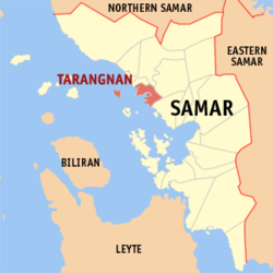
Basisdaten Bezirk: Eastern Visayas Provinz: Samar Barangays: 41 Distrikt: 1. Distrikt von Samar PSGC: 086020000 Einkommensklasse: 4. Einkommensklasse Haushalte: 4020 Zensus 1. Mai 2000Einwohnerzahl: 22.767 Zensus 1. August 2007Koordinaten: 11° 54′ N, 124° 45′ O11.9124.75Koordinaten: 11° 54′ N, 124° 45′ O Postleitzahl: 6704 Bürgermeister: Emmelly D. Olaje Offizielle Webpräsenz: Tarangnan Geographische Lage auf den Philippinen 

Tarangnan Tarangnan ist eine philippinische Stadtgemeinde in der Provinz Samar. Nach dem Zensus vom 1. Mai 2000 hat sie 20.538 Einwohner in 4020 Haushalten.
Baranggays
Tarangnan ist politisch in 41 Baranggays unterteilt.
- Alcazar
- Awang
- Bahay
- Balonga-as
- Balugo
- Bangon Gote
- Baras
- Binalayan
- Bisitahan
- Bonga
- Cabunga-an
- Cagtutulo
- Cambatutay Nuevo
- Cambatutay Viejo
- Canunghan
- Catan-agan
- Dapdap
- Gallego
- Imelda Pob. (Posgo)
- Lucerdoni (Irong-irong)
- Lahong
- Libucan Dacu
- Libucan Gote
- Majacob
- Mancares
- Marabut
- Oeste - A
- Oeste - B
- Pajo
- Palencia
- Poblacion A
- Poblacion B
- Poblacion C
- Poblacion D
- Poblacion E
- San Vicente
- Santa Cruz
- Sugod
- Talinga
- Tigdaranao
- Tizon
Städte und Stadtgemeinden in der Provinz SamarStädte: Calbayog City | Catbalogan City
Stadtgemeinden: Almagro | Basey | Calbiga | Daram | Gandara | Hinabangan | Jiabong | Marabut | Matuguinao | Motiong | Pagsanghan | Paranas | Pinabacdao | San Jorge | San Jose De Buan | San Sebastian | Santa Margarita | Santa Rita | Santo Niño | Tagapul-an | Talalora | Tarangnan | Villareal | Zumarraga
Wikimedia Foundation.
Schlagen Sie auch in anderen Wörterbüchern nach:
Tarangnan — Original name in latin Tarangnan Name in other language Taranga, Tarangan, Tarangnan State code PH Continent/City Asia/Manila longitude 11.9009 latitude 124.7459 altitude 7 Population 2762 Date 2011 07 31 … Cities with a population over 1000 database
Tarangnan, Samar — Tarangnan is a 5th class municipality in the province of Samar, Philippines. According to the 2000 census, it has a population of 20,538 people and 4,020 households. History On the earlier part of the 18th century, Tarangnan was the first… … Wikipedia
Samar — This article is about the province. For other uses, see Samar (disambiguation). Samar Province … Wikipedia
Legislative districts of Samar — Philippines This article is part of the series: Politics and government of the Philippines … Wikipedia
Catbalogan City — Lage von Catbalogan City in der Provinz Samar Basisdaten Bezirk: Ost Samar … Deutsch Wikipedia
PH-WSA — Lage der Provinz Samar Die Provinz Samar, lange Zeit unter der Bezeichnung Western Samar bekannt, ist eine Provinz der Philippinen und gehört politisch dem Bezirk Eastern Visayas (Region VIII) an. Die Hauptstadt von Samar ist Catbalogan City,… … Deutsch Wikipedia
Western Samar — Lage der Provinz Samar Die Provinz Samar, lange Zeit unter der Bezeichnung Western Samar bekannt, ist eine Provinz der Philippinen und gehört politisch dem Bezirk Eastern Visayas (Region VIII) an. Die Hauptstadt von Samar ist Catbalogan City,… … Deutsch Wikipedia
Daram, Samar — Daram is a 4th class municipality in the province of Samar, Philippines. According to the 2000 census, it has a population of 35,532 people in 6,472 households. Barangays Daram is politically subdivided into 58 barangays. Arawane Astorga Bachao… … Wikipedia
Marabut, Samar — Marabut is a 5th class municipality in the province of Samar, Philippines. According to the 2000 census, it has a population of 12,334 people in 2,383 households. Contents 1 History 2 Barangays 3 … Wikipedia
Matuguinao, Samar — Matuguinao is a 5th class municipality in the province of Samar, Philippines. According to the 2000 census, it has a population of 5,361 people in 875 households. Barangays Matuguinao is politically subdivided into 20 barangays. Angyap Barruz… … Wikipedia
Tarangnan


18+
© Academic, 2000-2026
- Kontaktieren Sie uns: Unterstützung, Werbung
Wörterbücher Export, schritte mit PHP, Joomla, Drupal, WordPress, MODx.