Bandelier Wilderness

Bandelier Wilderness
Bandelier National Monument
Frijoles-Schlucht
Frijoles-Schlucht
Bandelier National Monument
Karte der USA
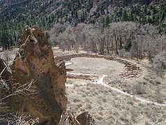
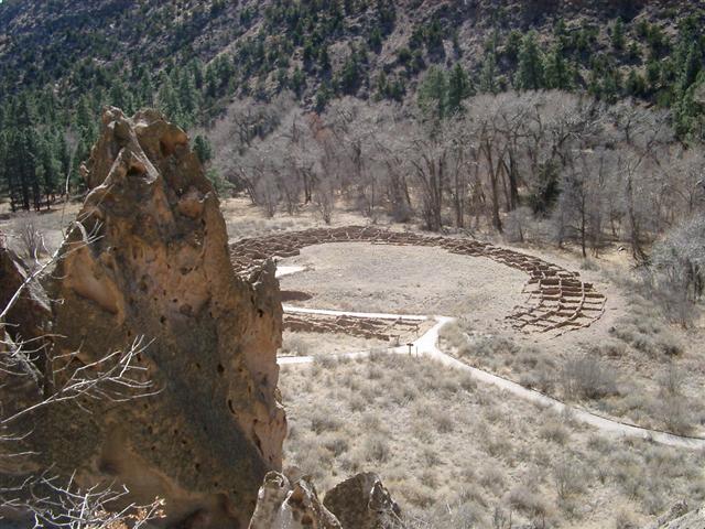
Lage: New Mexico, USA
Nächste Stadt: Santa Fe (New Mexico)
Fläche: 136,3 km²
Gründung: 11. Februar 1916
Besucher: 260.942 (2004)

Das Bandelier National Monument ist sowohl Gedenkstätte wie Naturschutzgebiet vom Typ eines National Monument im Norden New Mexicos, USA mit einer Fläche von ungefähr 136 km². Mehr als zwei Drittel davon (95km²) stehen als Bandelier Wilderness unter dem weitergehenden Schutz eines Wilderness Areas. Die Hauptattraktion des National Monuments ist die Frijoles-Schlucht. Sie war zwischen 1100 und etwa 1550 von Vorläufern der Pueblo-Kultur besiedelt. Im Gebiet sind über 1000 Siedlungsorte nachweisbar, im größten Tyuoyi Pueblo kann man Gemeinschaftshaus und Zeremonienhöhle sehen. Im Süden liegt die Painted Cove, eine Höhle mit prähistorischen Petroglyphen.

Das Areal ist seit 1916 ein National Monument und wurde nach dem Anthropologen Adolph Bandelier benannt. Während des Zweiten Weltkriegs war es mehrere Jahre für die Öffentlichkeit gesperrt, damals lebten einige Wissenschaftler des Manhattan-Projekts aus dem nahegelegenen Los Alamos National Laboratory hier. Das Wildnisschutzgebiet kam im Oktober 1976 hinzu.

Weblinks

35.793763216667-106.275944711117Koordinaten: 35° 47′ 38″ N, 106° 16′ 33″ W


Wikimedia Foundation.

Игры ⚽ Нужна курсовая?

Schlagen Sie auch in anderen Wörterbüchern nach:

  • Bandelier-Nationalmonument — Bandelier National Monument Frijoles Schlucht …   Deutsch Wikipedia

  • Bandelier National Monument — Frijoles Schlucht …   Deutsch Wikipedia

  • Bandelier National Monument — For the anthropologist, see Adolph Bandelier.Infobox protected area | name = Bandelier National Monument iucn category = III caption = locator x = 88 locator y = 108 location = Sandoval County Los Alamos County, New Mexico, USA nearest city = Los …   Wikipedia

  • Bandelier National Monument — Archaeological area, north central New Mexico, U.S. Lying along the Rio Grande 20 mi (32 km) northwest of Santa Fe, it was established in 1916. It occupies an area of 51 sq mi (132 sq km) and was named for Adolph Bandelier, a Swiss American… …   Universalium

  • Dome Wilderness — IUCN Category Ib (Wilderness Area) …   Wikipedia

  • List of National Monuments of the United States — The United States has 101 protected areas known as national monuments. The President of the United States can establish a national monument by executive order, and the United States Congress can by legislation. The Antiquities Act of 1906… …   Wikipedia

  • National Park Service rustic — National Park Service rustic, also colloquially known as Parkitecture, is a style of architecture that arose in the United States National Park System to create buildings that harmonized with their natural environment. Since its founding, the… …   Wikipedia

  • Coronado National Forest — IUCN Category VI (Managed Resource Protected Area) …   Wikipedia

  • Ocmulgee National Monument — IUCN Category V (Protected Landscape/Seascape) Great Temple Mound …   Wikipedia

  • List of New Mexico-related topics — The following is a list of topics about the U.S. State of New Mexico. NOTOC compactTOC4 0–9*2008 prison break in Clovis, New Mexico *32nd meridian west from Washington *47th State to join the United States of AmericaA [ 33 counties of the State… …   Wikipedia

Share the article and excerpts

Direct link
Do a right-click on the link above
and select “Copy Link”