Thinali

Thinali
Stadtgemeinde Thinali
(1989–2010)

Δήμος Θιναλίων (Θινάλι)
Thinali (Griechenland)
Bluedot.svg
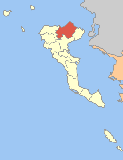
Basisdaten
Staat: Griechenland
Verwaltungsregion: Ionische Inseln
Präfektur: Korfu
Geographische Koordinaten: 39° 45′ N, 19° 47′ O39.75388888888919.780555555556Koordinaten: 39° 45′ N, 19° 47′ O
Höhe ü. d. M.: etwa 300 m
Fläche: 77,9 km²
Einwohner: 5.512 (2001[1])
Bevölkerungsdichte: 70,8 Ew./km²
Sitz: Nymfes
LAU-1-Code-Nr.: 220500
Gemeindegliederung: 11 Gemeindebezirke
Website: www.corfu-north.com
Lage in der ehem. Präfektur Korfu
Bild:Dimos Thinaliou.png

f10

Thinali (griechisch Θινάλι (n. sg.)) war eine Gemeinde im Norden der Insel Korfu in Griechenland. Sie wurde 1989 als Dimos Thinalion aus dem Zusammenschluss zahlreicher Dörfer gegründet und ging 2010 in der neu gebildeten Großgemeinde Korfu auf, in der es seither einen Gemeindebezirk (Dimotiki enotita Thinaliou Δημοτική ενότητα Θιναλίου) bildet.

Inhaltsverzeichnis

Ortschaften und Siedlungen

  • Agios Pandeleimonas
    • Acharavi
    • Fourni
    • Lazaratika
    • Priftiatika
    • Strongyli
    • Vrachleri
  • Episkepsi
  • Klimatia
    • Klimatia
    • Episkopi
    • Kyprianades
  • Lafki
    • Lafki
    • Agios Martinos
    • Psachnia
    • Trimodi
  • Loutses
    • Loutses
    • Anapaftiria
    • Apraos
    • Magarika
  • Nymfes
  • Perithia
    • Perithia
    • Agios Ilias
    • Karniaris
    • Krinias
    • Pelekito
    • Perouli
    • Pithos
    • Riliatika
    • Vasilika
    • Vathy
    • Vouni
  • Petalia
    • Petalia
    • Drosseri
    • Eriva
    • Perama
    • Strinyla
  • Sfakera
    • Sfakera
    • Roda
  • Xanthates

Einwohnerentwicklung

Thinali hatte 1991 noch 5.386 Einwohner; diese Zahl erhöhte sich bis 2001 um 126 auf 5.512.

Einzelnachweise

  1. Informationen des griechischen Statistischen Dienstes

Weblinks


Wikimedia Foundation.

Игры ⚽ Поможем написать реферат

Schlagen Sie auch in anderen Wörterbüchern nach:

  • Thinali — (Greek, Modern: Θινάλι), older form: on is a municipality in the Corfu Prefecture, Greece. It is located in the northernmost part of the island of Corfu. It is the largest municipality in the prefecture in land area at 77.899 km². Its population… …   Wikipedia

  • Nymfes — Νύμφες Location …   Wikipedia

  • Corfu — For other uses, see Corfu (disambiguation). Corfu Κέρκυρα Pontikonisi and Vlacheraina monastery seen from the hilltops of Kanoni …   Wikipedia

  • Kassopaia — Kassopaia, also Kasopaia, Kassopea and Kasopea, rarely Kassiopi and Kasiopi (Greek: Κασσωπαία) is a municipality in the Corfu Prefecture, Greece. It is located in the northeasternmost tip of the island of Corfu. It has a land area of 33.749 km²… …   Wikipedia

  • GR-22 — Präfektur Korfu Νομός Κέρκυρας Basisdaten Staat: Griechenland V …   Deutsch Wikipedia

  • Parelioi — Gemeinde Parelii Δήμος Παρελίων (Παρέλιοι) DEC …   Deutsch Wikipedia

  • Strogili — Strongyli (griechisch Στρογγύλη (f. sg.)) ‚die Runde‘) bezeichnet einige griechische Inseln der Südlichen Sporaden Strongyli (Megisti) bei Kastelorizo ein unbewohntes Felseneiland vor der Nordostspitze der Insel Kasos ein unbewohntes Felseneiland …   Deutsch Wikipedia

  • Strongili — Strongyli (griechisch Στρογγύλη (f. sg.)) ‚die Runde‘) bezeichnet einige griechische Inseln der Südlichen Sporaden Strongyli (Megisti) bei Kastelorizo ein unbewohntes Felseneiland vor der Nordostspitze der Insel Kasos ein unbewohntes Felseneiland …   Deutsch Wikipedia

  • Nome de Corfou — 39°40′N 19°45′E / 39.667, 19.75 …   Wikipédia en Français

  • List of municipalities and communities in Greece — This is an alphabetical list of municipalities and communities in Greece. For an ordered list of cities with population over 30,000 see List of cities in Greece. A B C D E F G H I K L M N O P R S T V X Y Z See also A Name Greek name Prefecture A …   Wikipedia

Share the article and excerpts

Direct link
Do a right-click on the link above
and select “Copy Link”