Tilla Jogian

Tilla Jogian
Tilla Jogian
Tilla Jogian.jpg
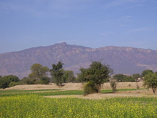
Höhe 975 m
Lage Pakistan
Gebirge Salzgebirge
Geographische Lage 32° 50′ 0″ N, 73° 25′ 0″ O32.83333333333373.416666666667975Koordinaten: 32° 50′ 0″ N, 73° 25′ 0″ O
Tilla Jogian (Pakistan)
Tilla Jogian

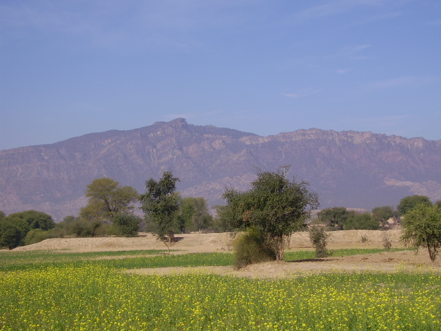
Tilla Jogian ist eine Erhebung in den östlichen Ausläufern des Salzgebirges im Norden der pakistanischen Provinz Punjab. Sie liegt etwa 25 Kilometer westlich der Stadt Jehlam. Der Berg ist benannt nach dem vom bekannten Yogi Goraknath erbauten Mönchs-Kloster. Die Überreste des Klosters sind noch heute zu sehen. An der Ostseite befindet sich das um 1540 von Sher Shah Suri erbaute Rohtas (auch Qila Rhotas genannt), welches heute eines der wichtigsten pakistanischen Denkmäler darstellt und 1997 von der UNESCO zum Weltkulturerbe erklärt wurde.

In der Nähe von Tilla Jogian befindet sich ein Startplatz für die Erprobung militärischer Raketen. Diese Anlage wird – je nach Quelle – auch als Tulla, Malute, Malot, Jhelum oder Dina bezeichnet. Von diesem Ort startete am 6. April 1998 die pakistanische Ghauri-1 Mittelstreckenrakete zu ihrem ersten Testflug. (siehe auch: Raketenstartplätze)

Weblinks


Wikimedia Foundation.

Игры ⚽ Поможем написать курсовую

Schlagen Sie auch in anderen Wörterbüchern nach:

  • Tilla Jogian — is the highest peak in the Eastern Salt Range in Punjab, Pakistan. At 975 meters (3200ft) above sea level, it is about 25 km to the west of Jhelum city and 10 km west of the model village of Khukha. The view from the top of Tilla is highly… …   Wikipedia

  • Tilla — ist der Vorname folgender Personen: Tilla Durieux (1880–1971), eigentlich Ottilie Godeffroy; österreichische Schauspielerin Tilla Theus (* 1943), schweizerische Architektin der Künstlername des Travestiekünstlers Johann Baptist Welsch (1888–1943) …   Deutsch Wikipedia

  • Tilla — is an eastward continuation of the Salt Range in Jhelum District, Punjab, Pakistan, 3,242 feet above the sea. From the Bunha torrent the range rises rapidly to the culminating peak of Tilla Jogian and thence sinks as rapidly, but a series of low… …   Wikipedia

  • Salzgebirge — p1f1 Salzgebirge Höchster Gipfel Sakaser (1.522 m) Lage Pakistan …   Deutsch Wikipedia

  • Jhelum — For other uses, see Jhelum (disambiguation). Coordinates: 32°55′43″N 73°43′53″E / 32.92861°N 73.73139°E / 32.92861; 73.73139 …   Wikipedia

  • Raketenstartplätze — Ein Raketenstartplatz, eine Einrichtung zum Start von Raketen stellt eine oder mehrere Abschussrampen und Startleitstände zur Kontrolle der Startprozedur zur Verfügung. Für Flüssigkeitsraketen sind auch Anlagen zur Lagerung und gegebenenfalls… …   Deutsch Wikipedia

  • Jhelum District — For other uses, see Jhelum (disambiguation). Jhelum   District   Nickname(s) …   Wikipedia

  • Bhera — is a town in the Punjab province of Pakistan. It is located on the Jhelum river in Sargodha District, at latitude 32.48 N, longitude 72.92 E. Pop. (1901) 18,680. It is the terminus of a branch of the North Western Railway. It is an important… …   Wikipedia

  • Khukha — is a big village in Jhelum District, Punjab, Pakistan. It is a Union Council, an administrative subdivision, of Jhelum Tehsil [ [http://www.nrb.gov.pk/lg election/union.asp?district=12 dn=Jhelum Tehsils Unions in the District of Jhelum Government …   Wikipedia

  • Rohtas Fort — Infobox World Heritage Site WHS = Rohtas Fort State Party = PAK Type = Cultural Criteria = ii, iv ID = 586 Region = Asia Pacific Year = 1997 Session = 21st Link = http://whc.unesco.org/en/list/586Rohtas Fort ( ur. قلعہ روہتاس Qila Rohtas ) is a… …   Wikipedia

Share the article and excerpts

Direct link
Do a right-click on the link above
and select “Copy Link”