Two Bush Island

Two Bush Island

Vorlage:Infobox Insel/Wartung/Bild fehltVorlage:Infobox Insel/Wartung/Fläche fehltVorlage:Infobox Insel/Wartung/Höhe fehlt

Two Bush Island
Gewässer Atlantischer Ozean
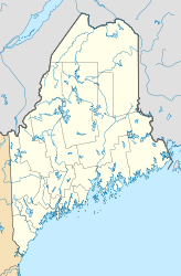
Geographische Lage 43° 57′ 51,74″ N, 69° 4′ 25,51″ W43.964372-69.073754Koordinaten: 43° 57′ 51,74″ N, 69° 4′ 25,51″ W
Two Bush Island (Maine)
Two Bush Island
Einwohner (unbewohnt)

Two Bush Island (von: zwei den Seglern als Orientierung dienenden Kiefern. 1820 noch eine vorhanden.) ist der Name einer Insel und des darauf befindlichen Leuchtturms in Maine. Das eckige Ziegelgebäude markiert das nördliche Ende des Two Bush Channel und die Ostseite des Eingangs in den Muscle Ridge Channel, der in die Penobscot Bay führt.

Der Leuchtturm wurde 1897 errichtet, 1963 erfolgte die Umstellung auf automatischen Betrieb. Im Verlauf der folgenden Jahre plante die United States Coast Guard den Abriss des Wärterhauses und der Nebengebäude, aber bis zum Ende des Jahrzehnts fand sich niemand, der im Rahmen der Richtlinien und unter Einhaltung des Budgets diese Aufgabe übernehmen wollte. Anfang des folgenden Jahrzehnts erfolgte deshalb die Sprengung durch die in Massachusetts stationierte 10th Special Forces Group der U.S. Army, welche zu bedeutenden, aber nur oberflächlichen Beschädigungen des Turms und der Laterne führte.

Seitdem steht die gesamte Insel unter Verwaltung des United States Fish and Wildlife Service, der hier ein Schutzgebiet betreibt.

Der Leuchtturm sendet von einer Laterne in Höhe von ca. 21 m (65 Fuß) über dem Meeresspiegel ein weißes Blinklicht mit einem roten Abschnitt aus.

Der Turm kann von der Rackliff Island Road in Spruce Head beobachtet werden, jedoch befindet er sich ca. 6,3 km (4,1 Meilen) südöstlich; die Lively Lady Too bietet von Camden im Rahmen von Lighthouse Cruises Möglichkeiten einer genaueren Betrachtung.

Weblinks


Wikimedia Foundation.

Игры ⚽ Нужно решить контрольную?

Schlagen Sie auch in anderen Wörterbüchern nach:

  • Island fox — Island fox[1] Conservation status …   Wikipedia

  • Deer Island Thorofare Light — Location Penobscot Bay, Maine Coordinates …   Wikipedia

  • Bush Heritage Australia — is a non profit organisation based in Melbourne, Victoria, Australia that operates throughout Australia. It was previously known as the Australian Bush Heritage Fund, which is still its legal name. It purchases land, assessed as being of… …   Wikipedia

  • Two Peoples Bay Nature Reserve — Two Peoples Bay is a protected area located convert|35|km|mi|0 east of Albany. The area is accessible by 2WD vehicles. The bay itself, including two small secluded beaches, faces due east and is protected from the powerful Southern Ocean by a… …   Wikipedia

  • Manana Island Sound Signal Station — US Coast Guard photo Location Manana Island, Maine Year first constructed 1855 Automated 1988 Tower shape Brick House Markings / pattern Brown …   Wikipedia

  • Monhegan Island Light — Location Monhegan Island, Maine Year first constructed 1824 Year first lit 1850 (current structure) Automated 1959 Foundation Surface rock Construction Granite blocks Tower shape Cy …   Wikipedia

  • Curtis Island Light — US Coast Guard photo Location Camden, Maine Year first constructed 1835 Year first lit 1896 (current structure) Automated 1972 Tower shape Cylindrical Brick Tower …   Wikipedia

  • Nash Island Light — US Coast Guard photo Location Pleasant Bay, Maine Coordinates …   Wikipedia

  • Ein Sommer in Long Island — Filmdaten Originaltitel Ein Sommer in Long Island Produktionsland Deutschland …   Deutsch Wikipedia

  • Bush family — The Bush Family The Bush family in the Red Room of the White House (January 2005). Seated left to right: Marvin Bush, Laura Bush, George W. Bush, Barbara Bush, George H. W. Bush, Jeb Bush. Also p …   Wikipedia

Share the article and excerpts

Direct link
Do a right-click on the link above
and select “Copy Link”