- Uttlesford
-
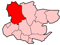
Uttlesford District 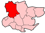
Lage in EssexStatus District Region East of England Verw.grafschaft Essex Verwaltungssitz Saffron Walden Fläche 641,18 km² (66.) Einwohner 72.500 (311.) ONS-Code 22UQ Website www.uttlesford.gov.uk Uttlesford ist ein District in der Grafschaft Essex in England. Der Verwaltungssitz ist Saffron Walden; weitere bedeutende Orte sind Felsted, Flitch Green, Great Dunmow, Stebbing, Stansted Mountfitchet und Thaxted.
Der Bezirk wurde am 1. April 1974 gebildet und entstand aus der Fusion des Borough Saffron Walden sowie der Rural Districts Dunmow und Saffron Walden. 2001 ergab eine Umfrage der Zeitung Sunday Times, dass Uttlesford die Region mit der höchsten Lebensqualität in England ist. Ein wichtiger Arbeitgeber ist der Flughafen London-Stansted.

Basildon | Braintree | Brentwood | Castle Point | Chelmsford | Colchester | Epping Forest | Harlow | Maldon | Rochford | Tendring | Uttlesford

Wikimedia Foundation.