- Bauang
-
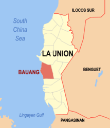
Municipality of Bauang Lage von Bauang in der Provinz La Union 
Basisdaten Bezirk: Ilocos-Region Provinz: La Union Barangays: 39 Distrikt: 2. Distrikt von La Union PSGC: 013307000 Einkommensklasse: 1. Einkommensklasse Haushalte: 12.298 Zensus 1. Mai 2000Einwohnerzahl: 69.837 Zensus 1. August 2007Bevölkerungsdichte: 975,4 Einwohner je km² Fläche: 71,60 km² Koordinaten: 16° 31′ N, 120° 19′ O16.516666666667120.31666666667Koordinaten: 16° 31′ N, 120° 19′ O Vorwahl: +63 72 Bürgermeister: Robert P. De Guzman Offizielle Webpräsenz: www.bauang.gov.ph Geographische Lage auf den Philippinen Bauang ist eine große Stadtgemeinde in der philippinischen Provinz La Union und liegt im Südchinesischen Meer. In Bauang arbeiten im Gegensatz zu anderen Stadtgemeinden der Provinz bereits einige Menschen in der Industrie oder Tourismusbranche. Das liegt unter anderem an den berühmten Stränden der Gemeinde und an der relativ guten Infrastruktur. Dennoch spielt die Landwirtschaft noch eine wichtige Rolle.
Bevölkerungsentwicklung
Jahr Einwohner 2000 63.373 2007 69.837 Baranggays
Bauang ist in folgende 39 Baranggays aufgeteilt:
- Acao
- Baccuit Norte
- Baccuit Sur
- Bagbag
- Ballay
- Bawanta
- Boy-utan
- Bucayab
- Cabalayangan
- Cabisilan
- Calumbaya
- Carmay
- Casilagan
- Central East
- Central West
- Dili
- Disso-or
- Guerrero
- Nagrebcan
- Pagdalagan Sur
- Palintucang
- Palugsi-Limmansangan
- Parian Oeste
- Parian Este
- Paringao
- Payocpoc Norte Este
- Payocpoc Norte Oeste
- Payocpoc Sur
- Pilar
- Pudoc
- Pottot
- Pugo
- Quinavite
- Lower San Agustin
- Santa Monica
- Santiago
- Taberna
- Upper San Agustin
- Urayong
Schlagen Sie auch in anderen Wörterbüchern nach:
Bauang — Original name in latin Bauang Name in other language State code PH Continent/City Asia/Manila longitude 16.53083 latitude 120.33306 altitude 13 Population 17109 Date 2011 07 31 … Cities with a population over 1000 database
Bauang, La Union — Infobox Philippine municipality infoboxtitle = Municipality of Bauang sealfile = region = Ilocos Region (Region I) province = La Union founded = 1590 pop2000 = 69,837 popden2000 = 975.38 areakm2 = 71.60 coordinates = 16°31 N 120°19 E barangays =… … Wikipedia
Naguilian, La Union — Naguilian Municipality Seal … Wikipedia
Schlacht um die Philippinen — Teil von: Zweiter Weltkrieg, Pazifikkrieg Gebiet der Philippinen … Deutsch Wikipedia
Ilokano writers — There are hundreds of published Ilokano writers (or Ilocano writers ) from the time Ilokano literature emerged through the efforts of Ilokano ilustrados in the 18th century to the present. The following list of Ilokano writers is not extensive… … Wikipedia
PH-LUN — Lage der Provinz La Union ist eine philippinische Provinz in dem Bezirk Ilocos auf der Hauptinsel Luzón. Die Provinzhauptstadt ist San Fernando. An La Union grenzen auch andere Provinzen, wie Ilocos Sur im Norden, Benguet im Osten und Pangasinán… … Deutsch Wikipedia
History of Basilan — Pre Hispanic TaguimaBasilan s earliest settlers were the Orang Dampuans originating from the islands of Eastern Indonesia, who were the ancestors of the native Yakans. They are variously called the Orang Dyaks or the Tagihamas.The Yakans, an… … Wikipedia
La Union — La Union, without an accented o, refers to a province in the Philippines. For places in Latin America and Spain, see La Unión. Infobox Philippine province name = La Union sealfile = Ph seal la union.png region = Ilocos Region (Region I) capital … Wikipedia
Ilocos Region — Region I Ilocos Region Region Map of the Philippines showing the location of Region I … Wikipedia
San Juan, La Union — Infobox Philippine municipality infoboxtitle = Municipality of San Juan sealfile = Ph seal la union san juan.jpg| locatormapfile = Ph locator la union san juan.png caption = Map of La Union showing the location of San Juan region = Region I… … Wikipedia

