- Wellingborough (Borough)
-
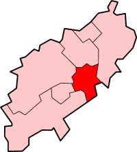
Borough of Wellingborough 
Lage in NorthamptonshireStatus Borough Region East Midlands Verw.grafschaft Northamptonshire Verwaltungssitz Wellingborough Fläche 163,04 km² (204.) Einwohner 75.900 (307.) ONS-Code 34UH Website www.wellingborough.gov.uk Wellingborough ist ein Verwaltungsbezirk mit dem Status eines Borough in der Grafschaft Northamptonshire in England. Verwaltungssitz ist die Stadt Wellingborough, in der etwa zwei Drittel der Bevölkerung lebt. Weitere bedeutende Orte sind Bozeat, Earls Barton, Irchester und Wollaston.
Der Bezirk wurde am 1. April 1974 gebildet und entstand aus der Fusion des ursprünglichen Borough of Wellingborough und des Rural District Wellingborough.
Corby | Daventry | East Northamptonshire | Kettering | Northampton | South Northamptonshire | Wellingborough
Wikimedia Foundation.
Schlagen Sie auch in anderen Wörterbüchern nach:
Wellingborough (borough) — Infobox UK district name = Borough of Wellingborough status = Borough region = East Midlands admincounty = Northamptonshire area = Ranked 204th 163.04 km² adminhq = Wellingborough onscode = 34UH population = Ranked English district rank|ONS=34UH… … Wikipedia
Wellingborough (borough) — 52°18′05″N 0°41′40″O / 52.30139, 0.69444 Wellingborough est un arrondissement du comté du Nort … Wikipédia en Français
Wellingborough — Coordinates: 52°17′38″N 0°41′47″W … Wikipedia
Wellingborough railway station — Infobox UK station name = Wellingborough manager = East Midlands Trains locale = Wellingborough borough = Wellingborough (borough) start = 1857 platforms = 3 usage0506 = 0.797 usage0607 = 0.882 latitude = 52.304 longitude = 0.6764 Wellingborough… … Wikipedia
Wellingborough — ▪ England, United Kingdom town and borough (district), administrative and historic county of Northamptonshire, England, situated east of Northampton along the River Nene. Wellingborough grew as a market town in the Middle Ages. After a fire … Universalium
Wellingborough (UK Parliament constituency) — UK constituency infobox Name = Wellingborough Map1 = Wellingborough Map2 = Northamptonshire Type = County Year = 1918 Entity =Northamptonshire County =Northamptonshire EP = East Midlands MP = Peter Bone Party = ConservativeWellingborough is a… … Wikipedia
Kettering (Borough) — Borough of Kettering Lage in Northamptonshire Status Borough Region East Midlands Verw.grafschaft Northamptonshire … Deutsch Wikipedia
Croyland Abbey, Wellingborough — Croyland Abbey. Croyland Abbey is an historic building, originally a manor house but now offices, in Wellingborough in the English county of Northamptonshire. The building is named after Croyland Abbey in Lincol … Wikipedia
Charnwood (borough) — For the electoral ward of Leicester, see Charnwood (ward). Borough of Charnwood Borough Shown within Leiceste … Wikipedia
Melton (borough) — For other uses, see Melton (disambiguation). Borough of Melton Borough Ent … Wikipedia
Wellingborough (Borough)
18+
© Academic, 2000-2026
- Kontaktieren Sie uns: Unterstützung, Werbung
Wörterbücher Export, schritte mit PHP, Joomla, Drupal, WordPress, MODx.