- West Caicos
-
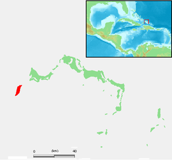
West Caicos Lage der Insel innerhalb der Turks- und Caicosinseln. Gewässer Atlantischer Ozean Inselgruppe Caicos-Inseln Geographische Lage 21° 40′ N, 72° 27′ W21.666666666667-72.45833333333310Koordinaten: 21° 40′ N, 72° 27′ W Länge 10,5 km Breite 2,2 km Fläche 28 km² Höchste Erhebung 10 m Einwohner (unbewohnt) Hauptort Yankee Town (historisch) West Caicos ist die westlichste Insel des britischen Überseegebiets der Turks- und Caicosinseln. Sie gehört zur Inselgruppe der Caicos-Inseln und liegt im Atlantik etwa 10 Kilometer südwestlich von Providenciales.
Die flache Insel ist seit knapp 100 Jahren unbewohnt. Sie wurde einst, ab etwa 1890, für einige Jahre zum großflächigen Anbau von Sisal sowie zum Betrieb von Salinen genutzt. Aus dieser Zeit finden sich heute nur noch wenige Relikte auf West Caicos, etwa verfallene Bauten und Gleisanlagen der damaligen "Hauptstadt" Yankee Town an der Westküste.
West Caicos dient derzeit vornehmlich als Naturreservat für zahlreiche Seevögel. Es ist allerdings geplant, eine große Hotelanlage auf der Insel zu errichten.
Weblinks
- Offizielle Website (engl.)
- Nutzung der Insel als Hotelanlage (engl.)
Turks-Inseln: Grand Turk | Salt Cay | Cotton Cay | East Cay | Gibbs Cay
Caicos-Inseln: West Caicos | Providenciales | Water Cay | Pine Cay | Stubbs Cay | Fort George Cay | Dellis Cay | Parrot Cay | North Caicos | Middle Caicos | East Caicos | South Caicos | Long Cay | Ambergris Cays
Wikimedia Foundation.
Schlagen Sie auch in anderen Wörterbüchern nach:
West Caicos — is an island in the Turks and Caicos Islands. West Caicos has an area of convert|11|sqmi|km2|0, and has been uninhabited for over a century. The island is home to the 500 acre (2 km²) Lake Catherine, a protected wildlife reserve, filled with pink … Wikipedia
West Caicos — Géographie Pays Royaume Uni Archipel Îles Turques et Caïques … Wikipédia en Français
Caicos del Oeste — West Caicos (también conocido en castellano como Caicos Occidental o Caicos del Oeste) es una isla en las Islas Turcas y Caicos. West Caicos, tiene un área de 11 millas cuadradas (28 km2), y ha estado deshabitada durante más de un siglo. La isla… … Wikipedia Español
Caicos-Inseln — Karte der Turks und Caicosinseln Gewässer Atlantischer Ozean … Deutsch Wikipedia
West — (en inglés Oeste) hace referencia a varios artículos en la wikipedia: Contenido 1 Lugares 1.1 Europa 1.2 Norteamérica 2 Música … Wikipedia Español
Caicos — ► Grupo de islas británicas en el extremo SE del archipiélago de las Bahamas; 4 315 h. Las principales son: North Caicos, South Caicos, Middle Caicos, East Caicos, West Caicos y Providenciales. (V. Turks.) … Enciclopedia Universal
West Indies — West Indian. 1. Also called the Indies. an archipelago in the N Atlantic between North and South America, comprising the Greater Antilles, the Lesser Antilles, and the Bahamas. 2. Federation of. Also called West Indies Federation. a former… … Universalium
West Indies Federation — Infobox Former Country native name = conventional long name = West Indies Federation common name = West Indies continent = North America region = Caribbean status = Federation event start = year start = 1958 date start = January 3 year end = 1962 … Wikipedia
Turks and Caicos Islands — /terrks; kuy kohs, kay / two groups of islands in the SE Bahamas: British crown colonies. 5675; ab. 166 sq. mi. (430 sq. km). Cap.: Grand Turk. * * * Turks and Caicos Islands Introduction Turks and Caicos Islands Background: The islands were part … Universalium
Districts of the Turks and Caicos Islands — Administrative Districts The Turks and Caicos Islands are divided into six administrative districts (two in the Turks Islands and four in the Caicos Islands), headed by District Commissioners (the area figures were determined by information in… … Wikipedia