Whanganui Island

Whanganui Island

Vorlage:Infobox Insel/Wartung/Bild fehltVorlage:Infobox Insel/Wartung/Höhe fehlt

Whanganui Island
Gewässer Pazifischer Ozean
Geographische Lage 36° 47′ 0″ S, 175° 26′ 0″ O-36.783333333333175.43333333333Koordinaten: 36° 47′ 0″ S, 175° 26′ 0″ O
Whanganui Island (Neuseeland)
Whanganui Island
Fläche 2,83 km²

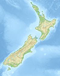
Whanganui Island ist die größte Insel einer kleinen Inselgruppe an der Mündung zum Hafen von Coromandel im Hauraki-Golf vor der Küste der Nordinsel Neuseelands.

Die Insel ist 2,83 km² groß. Der größte Teil ist landwirtschaftlich genutzt, es gibt aber auch einige bewaldete Gebiete.

Die Insel war bis zur Unterzeichnung des Vertrages von Waitangi Eigentum eines amerikanischen Siedlers, danach gehörte sie der britischen Krone, heute ist sie Privateigentum. Die Bucht Woolshed Bay an der geschützten Südküste ist ein beliebter Ankerplatz für Segler aus Auckland.


Wikimedia Foundation.

Игры ⚽ Нужно сделать НИР?

Schlagen Sie auch in anderen Wörterbüchern nach:

  • Whanganui Island — is the largest of a small group of islands at the entrance to Coromandel harbour in the Hauraki Gulf, off the coast of New Zealand s North Island.The island, which is privately owned, is 2.83 square kilometres in area. Much of it is farmed, but… …   Wikipedia

  • Whanganui — Various places in New Zealand are called Whanganui:*Whanganui Island *Whanganui National Park *Whanganui River*Te Whanganui a Hei, Maori for Cathedral Cove, a famous sea cave *Te Whanganui a Tara, Maori for Wellington, New Zealand s capital city… …   Wikipedia

  • Whanganui — River Carte du Whanganui et ses affluents. Caractéristiques Longueur 290 km Bassin  ? Débit moyen …   Wikipédia en Français

  • Whanganui-Nationalpark — Whanganui River …   Deutsch Wikipedia

  • Whanganui River — und Wanganui Stadt vom Durie Hill aus gesehen.Vorlage:Infobox Fluss/KARTE fehlt …   Deutsch Wikipedia

  • Whanganui River — The Whanganui River is a major river in the North Island of New Zealand. Known for many years as the Wanganui River , the river s name reverted to Whanganui in 1991, according with the wishes of local iwi. Part of the reason was also to avoid… …   Wikipedia

  • Whanganui — Vorlage:Infobox Fluss/DGWK fehltVorlage:Infobox Fluss/QUELLHÖHE fehltVorlage:Infobox Fluss/HÖHENUNTERSCHIED fehltVorlage:Infobox Fluss/EINZUGSGEBIET fehltVorlage:Infobox Fluss/ABFLUSS fehltVorlage:Infobox Fluss/KARTE fehlt Whanganui River …   Deutsch Wikipedia

  • Whanganui (Fluss) — Vorlage:Infobox Fluss/DGWK fehltVorlage:Infobox Fluss/QUELLHÖHE fehltVorlage:Infobox Fluss/HÖHENUNTERSCHIED fehltVorlage:Infobox Fluss/EINZUGSGEBIET fehltVorlage:Infobox Fluss/ABFLUSS fehltVorlage:Infobox Fluss/KARTE fehlt Whanganui River …   Deutsch Wikipedia

  • Whanganui National Park — Daten und Fakten Gründung: 1986 Lage: Neuseeland Nordinsel Höhenlage: 500 bis 746 m ü. NN Fläche: 742 km² …   Deutsch Wikipedia

  • Whanganui Journey — The Whanganui Journey is a river journey along the Whanganui River in the North Island of New Zealand travelling by canoe or kayak. The route, starting at Taumarunui and finishing at Pipiriki, is 145 Km long and usually takes 5 days to complete.… …   Wikipedia

Share the article and excerpts

Direct link
Do a right-click on the link above
and select “Copy Link”