- A559
-
Basisdaten Gesamtlänge: 4,2 km (ohne L 124) Bundesland: Nordrhein-Westfalen Karte Anschlussstellen und Bauwerke Mautfrei
- Köln-Deutz 
- Severinsbrücke 
- Köln-Am Grauen Stein 
- Köln-Kalk 
- Köln-Vingst 

(-) Kreuz Gremberg 


(-) Gremberghoven 

(-) Dreieck Porz 
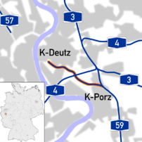
Die Bundesautobahn 559 (Abkürzung: BAB 559) – Kurzform: Autobahn 559 (Abkürzung: A 559) – verläuft von Süden her in Verlängerung der A 59 vom Autobahndreieck Porz nach Köln-Vingst.
Die A 59 zweigt am Dreieck Porz zum Dreieck Heumar ab, wo sie in die A 3/A 4 (Kölner Ring) einfädelt. Dieser Abzweig wurde Anfang der 80er Jahre freigegeben, um das Autobahnkreuz Gremberg zu entlasten.
Von Köln-Vingst führt die ebenfalls als Autobahn ausgebaute nordrhein-westfälische Landesstraße 124 weiter nach Köln-Deutz. Da dieser Abschnitt nicht zur Bundesautobahn gehört, ist er mautfrei und nicht als A 559 beschildert.
Weblinks
Gebaute Strecken:
Hauptstrecken: A 1 | A 2 | A 3 | A 4 | A 5 | A 6 | A 7 | A 8 | A 9Über- und regional: A 10 | A 11 | A 12 | A 13 | A 14 | A 15 | A 17 | A 19 | A 20 | A 21 | A 23 | A 24 | A 25 | A 26 | A 27 | A 28 | A 29 | A 30 | A 31 | A 33 | A 37 | A 38 | A 39 | A 40 | A 42 | A 43 | A 44 | A 45 | A 46 | A 48 | A 49 | A 52 | A 57 | A 59 | A 60 | A 61 | A 62 | A 63 | A 64 | A 65 | A 66 | A 67 | A 70 | A 71 | A 72 | A 73 | A 81 | A 92 | A 93 | A 94 | A 95 | A 96 | A 98 | A 99
Regional und lokal: A 100 | A 103 | A 111 | A 113 | A 114 | A 115 | A 117 | A 143 | A 210 | A 215 | A 226 | A 250 | A 252 | A 253 | A 255 | A 261 | A 270 | A 280 | A 281 | A 293 | A 352 | A 391 | A 392 | A 395 | A 445 | A 480 | A 485 | A 516 | A 524 | A 535 | A 540 | A 542 | A 544 | A 553 | A 555 | A 559 | A 560 | A 562 | A 565 | A 571 | A 573 | A 602 | A 620 | A 623 | A 643 | A 648 | A 650 | A 656 | A 659 | A 661 | A 671 | A 672 | A 831 | A 861 | A 864 | A 952 | A 980 | A 995
Geplante oder ehemalige Strecken:
A 16 | A 17* | A 18 | A 22 | A 32 | A 34 | A 35 | A 36 | A 40* | A 41 | A 47 | A 50 | A 51 | A 53 | A 54 | A 55 | A 56 | A 69 | A 74 | A 75 | A 77 | A 80 | A 82 | A 83 | A 84 | A 85 | A 86 | A 87 | A 88 | A 89 | A 90 | A 91A 102 | A 104 | A 105 | A 106 | A 107 | A 140 | A 201 | A 205 | A 227 | A 241 | A 263 | A 282 | A 290 | A 314 | A 339 | A 369 | A 376 | A 388 | A 430 | A 432 | A 441 | A 441* | A 443 | A 451 | A 480* | A 533 | A 545 | A 552 | A 558 | A 580 | A 610 | A 621 | A 647 | A 652 | A 653 | A 654 | A 655 | A 680 | A 683 | A 687 | A 713 | A 720 | A 722 | A 731 | A 751 | A 752 | A 753 | A 828 | A 833 | A 834 | A 840 | A 860 | A 862 | A 863 | A 863* | A 881 | A 895 | A 921 | A 922 | A 942 | A 944 | A 985 | A 990 | A 991 | A 992 | A 993 | A 994 | A 996 | A 997 | A 998 | A 999 | * frühere Planung: Nummer wurde später anders vergeben
Wikimedia Foundation.


