- Xunantunich
-
 Maya Ruinen von Xunantunich
 Maya-Tempel
 Xuanantunich-Eingang
 Xunantunich-ElCastillo
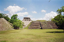
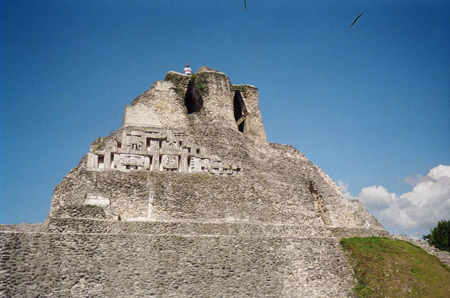
Die Maya-Ruinen von Xunantunich liegen ca. 13 Kilometer westlich von San Ignacio in Belize (Mittelamerika) auf einer Geländestufe über dem Mopan-Fluss. Der Name ist modern.
Um sechs Plazas gruppieren sich insgesamt über 25 Tempel und Palastbauten. Das auffälligste Gebäude mit rund 40 m Höhe über dem Gelände findet sich am Südrand der Ausgrabung - die Pyramide El Castillo. Bemerkenswert sind am El Castillo das rekonstruierte Stuckfries auf der Ostseite und die neue Friesreplik auf der Westseite.
Am Nordrand des zentralen Gebietes von Xunantunich befand sich ein Palastbau (Gebäude A11), das schon vor der Aufgabe der Siedlung bewusst zerstört und mit Bruchsteinen angefüllt wurde, offenbar ein Zeichen einer abrupt veränderten soziopolitischen Situation. [1]
Die Anlage wurde um das Jahr 900 verlassen und in der Neuzeit durch Thomas Gann am Ende des 19. Jahrhunderts wiederentdeckt (die erste bekannte Fotografie stammt aus dem Jahr 1904). Archäologische Erforschung findet seit 1930 statt.
Inhaltsverzeichnis
Siehe auch
Literatur
- Joyce Kelly: An Archaeological Guide to Northern Central America: Belize, Guatemala, Honduras, and El Salvador. Univ.of Oklahoma Pr., Norman 1996, ISBN 0-8061-2858-5, S.65 -72.
Einzelnachweise
- ↑ Jason Yaeger: Revisiting the Xunantunich Palace: The 2003 excavations. Online-Publikation: www.famsi.org/reports/02082/index.html
Weblinks
 Commons: Xunantunich – Sammlung von Bildern, Videos und Audiodateien
Schlagen Sie auch in anderen Wörterbüchern nach:
Xunantunich — El Castillo de Xunantunich Nombre: Zona arqueológica de Xunantunich Ubicación Distrito de Cayo … Wikipedia Español
Xunantunich — (shoo NAHN too nich) is a Maya archaeological site in western Belize, about 80 miles (130 km) west of Belize City (Latitude : 17.083 , Longitude : 89.133), in the Cayo District. Xunantunich is located atop a ridge above the Mopan River, within… … Wikipedia
Xunantunich — 17°05′02″N 89°08′02″O / 17.08389, 89.13389 Xunantunich est un site archéologique maya proche de … Wikipédia en Français
Pre-Columbian Belize — Perhaps as early as 35,000 years ago, nomadic people came from Asia to the Americas across the frozen Bering Strait. In the course of many millennia, their descendants settled in and adapted to different environments, creating many cultures in… … Wikipedia
Glovers Reef — Belize … Deutsch Wikipedia
Caracol — This article is about the Maya archaeological site in Belize. For the military manoeuver, see Caracole. For other uses, see El Caracol (disambiguation). Coordinates: 16°45′50.14″N 89°7′3.33″W / … Wikipedia
Oxhuitza — Tempel in Caracol Die Maya Ruinen von Caracol befinden sich in der Provinz Cayo in Belize (Mittelamerika). Die Stätte befindet sich in den Ausläufern der Maya Mountains ungefähr 40 Kilometer südlich der Maya Ruine Xunantunich. Der Name Caracol… … Deutsch Wikipedia
Chaa Creek — Maya civiliza … Wikipedia
History of Belize — The history of Belize dates back thousands of years. The Maya civilization spread into the area of Belize between 1500 BC and AD 300 and flourished until about AD 1200. Several major archeological sites notably Caracol, Lamanai, Lubaantun, Altun… … Wikipedia
BZ-CY — Cayo Lage von Cayo in Belize Daten Hauptstadt San Ignacio … Deutsch Wikipedia
Xunantunich


18+
© Academic, 2000-2026
- Kontaktieren Sie uns: Unterstützung, Werbung
Wörterbücher Export, schritte mit PHP, Joomla, Drupal, WordPress, MODx.