Bet Island

Bet Island
Bet Island
(Bet Islet)
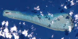
Landsat-Bild von Bet IslandBet Island ganz links, Vin Islet halb rechts.
Landsat-Bild von Bet Island
Bet Island ganz links, Vin Islet halb rechts.
Gewässer Pazifischer Ozean
Inselgruppe The Three Sisters
Geographische Lage 10° 8′ 45″ S, 142° 49′ 11″ O-10.145833333333142.819722222221Koordinaten: 10° 8′ 45″ S, 142° 49′ 11″ O
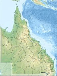
Bet Island(Bet Islet) (Queensland)
Bet Island(Bet Islet)
Fläche 0,1767 km²
Höchste Erhebung m
Einwohner (unbewohnt)
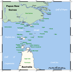
Lage der Torres-Strait-Inseln

Bet Island, auch Bet Islet genannt, ist eine australische Insel im Zentrum des Archipels der Torres-Strait-Inseln. Sie liegt im Norden der Inselgruppe The Three Sisters und ist etwa 6,3 km von Sue Island, der einzig bewohnten Insel der "Three Sisters", entfernt.

Bet Island mit einer Landfläche von knapp 17,7 ha ist von einem dichten, 13 km langen und bis zu 3 km breiten Korallenriff (Bet Islet Reef) mit einer Fläche von 28,7 km² eingefasst. Außer Bet, das ganz im Westen liegt, befindet sich im Riff noch die kleine Insel Vin Islet, 10° 9′ S, 142° 55′ O-10.148888888889142.92333333333 auf dem östlichen Riffkranz, mit einer Fläche von einem Hektar.

Verwaltungstechnisch zählt Bet Island (nebst Vin Islet) zu den Central Islands, einer Inselregion im Verwaltungsbezirk Torres Shire von Queensland.

Siehe auch


Wikimedia Foundation.

Игры ⚽ Нужно решить контрольную?

Schlagen Sie auch in anderen Wörterbüchern nach:

  • Island Records discography — Given the longevity of the Island Records record label it is inevitable that a large amount of data has to be gathered, managed and presented not only correctly but also usably. To this end, the label s history (and this discography) can… …   Wikipedia

  • Bet-el — Bethel (auch Beth El oder Beth El; hebr. בית אל = Haus Gottes) ist ein biblischer Ortsname, siehe Bet El. Davon abgeleitet tragen auch weitere Personen, Orte oder Institutionen diesen Namen. Inhaltsverzeichnis 1 Institutionen 2 Ortsnamen 2.1… …   Deutsch Wikipedia

  • Warraber Island — w1 Sue Island Lage der Torres Strait Inseln Gewässer Pazifischer Ozean Inselgruppe …   Deutsch Wikipedia

  • Sassie Island — (Long Island) Landsat Bild von Sassie Island Gewässer Pazifischer Oze …   Deutsch Wikipedia

  • Sue Island — w1 Sue Island Landsat Bild von Sue Island Gewässer Pazifischer Ozean …   Deutsch Wikipedia

  • Pleasure Island (Walt Disney World Resort) — Pleasure Island was a section of the Walt Disney World Resort within the Downtown Disney shopping, dining and entertainment district. Stores on Pleasure Island are open from 10:30 a.m. to 2:00 a.m. and restaurants from 11:00 a.m. to 1:00 a.m.… …   Wikipedia

  • Long Island Motor Parkway — LIMP redirects here. For other uses, see Limp (disambiguation). Long Island Motor Parkway U.S. National Register of Historic Places …   Wikipedia

  • Lot-O-Bucks (Rhode Island) — Lot O Bucks was the Rhode Island Lottery s first terminal based jackpot game. It ended in 1995.Lot O Bucks used several different number matrixes, most recently a pick 5 of 40. It was a rare case of a pick 5 game that did not guarantee an all… …   Wikipedia

  • Downtown Disney Pleasure Island — Pour les articles homonymes, voir Pleasure Island. 28° 22′ 16″ N 81° 31′ 05″ W …   Wikipédia en Français

  • Aliyah Bet — (Hebrew: עלייה ב), meaning Aliyah B (bet being the second letter of the Hebrew alphabet) was the code name given to illegal immigration by Jews to the British Mandate of Palestine in violation of British restrictions against such immigration.It… …   Wikipedia

Share the article and excerpts

Direct link
Do a right-click on the link above
and select “Copy Link”