Betio

Betio

Vorlage:Infobox Insel/Wartung/Bild fehltVorlage:Infobox Insel/Wartung/Fläche fehltVorlage:Infobox Insel/Wartung/Höhe fehlt

Betio
Gewässer Pazifischer Ozean
Inselgruppe Tarawa
Geographische Lage 1° 21′ 22,56″ N, 172° 55′ 53,79″ O1.356266172.931607Koordinaten: 1° 21′ 22,56″ N, 172° 55′ 53,79″ O
Betio (Kiribati)
Betio
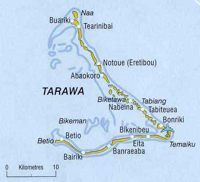
Karte des Atolls Tarawa

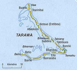
Betio ist eine Insel und zugleich ein Ort im Südwesten von Tarawa, einem Atoll im Pazifischen Ozean, und gehört zum Inselstaat Kiribati. Die Insel ist als „Haupttor“ Tarawas bekannt und beherbergt auch den Hafen des Atolls. Die Insel bildet den Betio Town Council (BTC).

Geschichte

Betio wurde bekannt als Schauplatz der Schlacht von Tarawa. Es gibt heute noch zahlreich Wracks in den Riffen der Insel. In den 1970er Jahren erlebte die kleine Insel einen Wirtschaftsboom und war die „Mitte“ der Wirtschaft von Kiribati. Betio galt in den 1980er Jahren als der am dichtesten besiedeltste Platz der Welt (2.500 Ew/km²).

Verbindungen zur Außenwelt

Betio hat einen befahrbaren Damm, der zu Bairiki führt. Außerdem befindet sich der Hafen des Inselstaates auf Betio.

Ämter

Das Amt für Tourismus sowie das Amt für den Handel haben ihren Sitz auf Betio.


Wikimedia Foundation.

Игры ⚽ Поможем написать реферат

Schlagen Sie auch in anderen Wörterbüchern nach:

  • Betio — is an island at the extreme southwest of South Tarawa. The main port of Tarawa Atoll is located here, and the island is most well known as being the scene of the Battle of Tarawa. [ [http://www.pacificwrecks.com/provinces/kiribati betio.html… …   Wikipedia

  • Betio — Saltar a navegación, búsqueda Mapa de Betio de la Segunda Guerra Mundial Betio es una isla en el extremo sudoeste de Tarawa, en el grupo de islas Gilbert, pertenecientes a Kiribati. El puerto principal de Tarawa se localiza aquí …   Wikipedia Español

  • Betio — 1°21′N 172°56′E / 1.35, 172.933 Betio est une île de l atoll de Tarawa, dans l archipel des îl …   Wikipédia en Français

  • Betio Village — Original name in latin Betio Village Name in other language State code KI Continent/City Pacific/Tarawa longitude 1.35797 latitude 172.92105 altitude 9 Population 12509 Date 2010 11 09 …   Cities with a population over 1000 database

  • Betio — geographical name islet & village W Pacific in N Kiribati at S end of Tarawa …   New Collegiate Dictionary

  • Bataille de Tarawa — Opération Galvanic Opération Galvanic Attaque de marines sur l archipel de Tarawa. Informations générales Date Du 21 au 23 novembre  …   Wikipédia en Français

  • Operation Galvanic — Opération Galvanic Opération Galvanic Attaque de marines sur l archipel de Tarawa. Informations générales Date Du 21 au 23 novembre  …   Wikipédia en Français

  • Opération Galvanic — 1°25′37.00″N 172°58′32.00″E / 1.4269444, 172.9755556 …   Wikipédia en Français

  • Battle of Tarawa — Coordinates: 1°25′37.00″N 172°58′32.00″E / 1.42694°N 172.97556°E / 1.42694; 172.97556 …   Wikipedia

  • Luftangriffe der Schlacht um die Gilbertinseln — Luftangriffe auf die Gilbertinseln Teil von: Zweiter Weltkrieg, Pazifikkrieg F6F Hellcat im Pazifik, 1943 …   Deutsch Wikipedia

Share the article and excerpts

Direct link
Do a right-click on the link above
and select “Copy Link”